Usually it's hard to find time to work on this blog. On the day I wrote the text for this post my van didn’t move; I rode my bike 10 miles and hiked
10 miles, which left me time in the evening. So I’ll at least get started on trying to get another post ready to
go. I’ve already uploaded most of the photos while I was camped in Sedona, AZ, at
a site with internet, so I’ll try to get some text written now, while I’m
camped with no cell coverage at Chaco Canyon, NM (which I’ll probably share 1
or 2 posts from now).
Taking stock...

By the time I get this posted I’ll have been full-timing
adventuring in my van for 7 months, having a great time. I’ve driven 14,600
miles, hiked at least 1,600 miles, and worn out a pair of hiking boots and 2
pairs of hiking shorts. I’ve burned off 14 pounds and one pants size. And did I
mention I love my van?? It makes an adventurous lifestyle easy. I almost feel
“soft” with my easy lifestyle, when I remember back to my long-distance
backpacking and bike tours. Yesterday I drove about 4 hours to get to my next
place to play, and all I had to do to set up camp when I got here was back into
my site, switch my fridge to propane, grab my hiking stuff and head out. I
hiked for about 4 hours and as sunset neared, the wind picked up, black clouds
rolled in, and the temperature dropped. I was a bit chilly when I got back to
my van so I fired up the propane heater and cooked dinner in the warmth.
Meanwhile the wind was blowing hard enough to rock my van and I doubt the tent
campers sitting around campfires were very comfy. If they hadn’t already
retired to their tents due to the wind chill, I’m sure the onset of heavy
rainfall, that lasted an hour, sent them scurrying to their sleeping bags. When
I was ready to call it a night, I crawled into a comfy bed with sheets, pillows, and a
down comforter. Today, overlooking Lake Powell in a raging windstorm that has already collapsed numerous tents within my view, and promises rain tonight, my van is rocking but I'm happily working at my table, watching the tent antics and enjoying the view of the lake and mountains. Life is good!
Picking up from my last post, with oodles of desert wild flowers,
I headed farther south in AZ to Picacho Peak State Park, rumored to be another amazing
place to see flowers. I hit it too early for flowers but it was a good hike
nonetheless. It’s a lone peak in the middle of ‘nowhere’ just north of Tucson.
It was 3 miles to the top with 1400’ elevation gain but the first 2 miles
didn’t gain much elevation; the last mile scaled to the top with the use of
numerous sets of cables.
 |
| And then the fun begins... |

 |
| There were 2 hiking clubs from Tucson heading down as I was going up. |

 |
| Picacho Peak stands all by itself in the middle of the desert near Tucon, AZ. |


Even though it was still "winter" (March 2nd),
the hiking temperatures were getting too warm for my taste so I opted to not go
any farther south. I headed north again to Superstition Wilderness Area, SE of
Scottsdale and hiked there for 10 days. It’s an incredible place to hike. I
started out based at a tourist trap ghost town/former mine that had a
campground (with corrals for horses, even). It was less expensive than the
State Park ½ mile away and the place had character (not to mention a great
shower and even a saloon/restaurant if one was so inclined). I rode my bike to
several trailheads from there and drove to one hike. I spent one night in the
state park (the only thing the touristy place didn’t have was a place to dump
my holding tanks).
 |
| Looking up at where I would hike the next day; up the draw in the middle to Flat Iron. |
 |
| It was once an active gold mine. |
 |
| You can ride your horse up to the saloon, hitch it to the hitching post and go in for a beer or meal. The campground also had corrals for horses $7/horse/night. |


 |
| I'm assuming this guy was part of the Wild West show complete with shoot out, offered to the tourists and he just happened to swing by the saloon to entertain some guests (and pick up a tip for his demonstration for the table). Either that or he's a wannabe cowboy. People watching here was entertaining. |
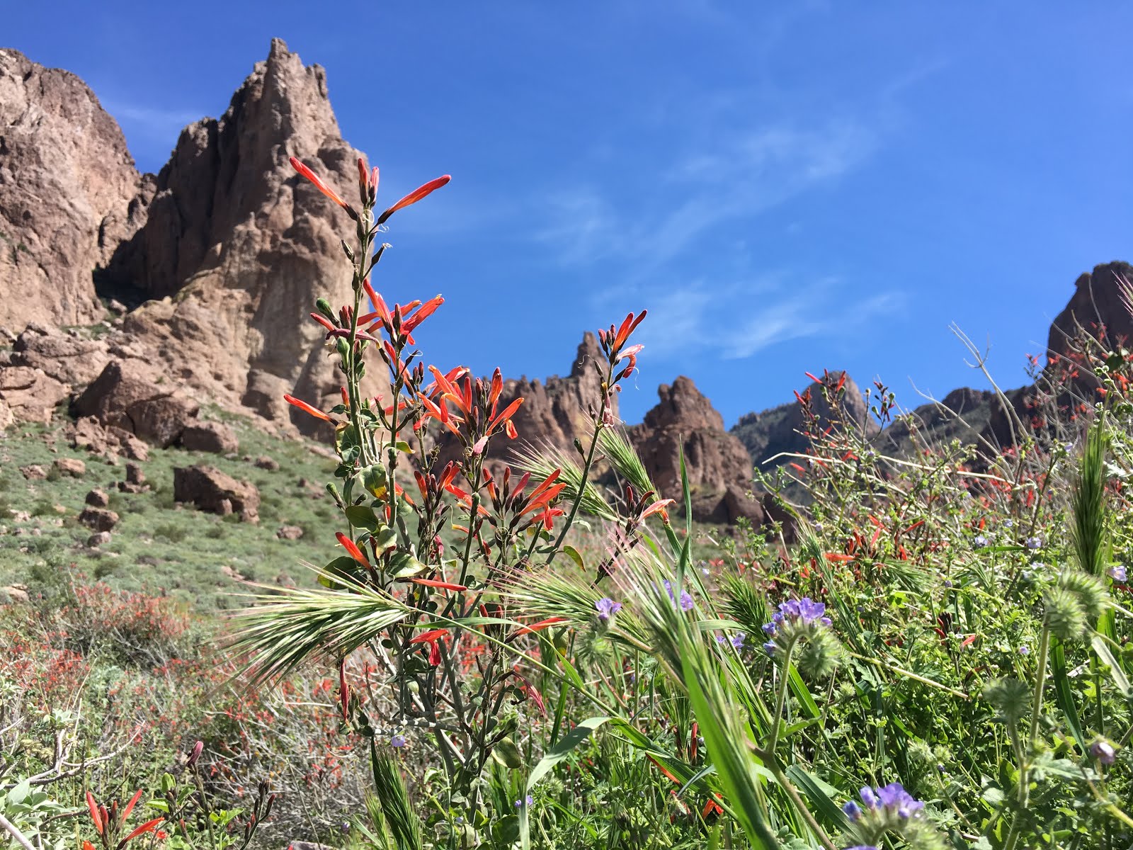
More flowers and scenic mountains but oh what a scramble to get up to Flat Iron -- a hike on a lot of people's bucket lists.
 |
| Hiking up Siphon Draw trail to Flatiron Peak. I thought this was the steep part but it got even steeper. It's 3900' elevation gain. |
 |
| It was the weekend; a lot of hikers tackle this one! |

 |
| Nice view. Then someone told me another 15 minutes and 400' elevation gain for a better view. |
 |
| The lower lip-looking peak in the middle is Flat Iron. Worth the extra hike up for more view! |
 |
I think this is called Web Mountain. Most hikers stop at Flat Iron.
|


 |
| The flowers aren't as thick as they were in White Tank Mountains but still nice. That's Flat Iron peak in the middle. |


 |
| I had to drive to the trail head for this hike starting at Canyon Lake along Hwy 88; a rough, windy road that has pitched multiple cars over the edge. But it was a great hike. |

 |
| A local hiker recommended that I go off trail to get to Lower LaBarge Canyon, promising that it would reveal the most beautiful place I'd ever been. It was pretty but in my mind didn't live up to the hype. |
 |
| There was boulder scrambling both in and beside the creek to get there. |


 |
| Sundial in Dutchman State Park. |
After a night at Walmart, a visit to REI to get new boots
and shorts and some RV repairs I headed to the south end of the Superstitions
and rattled my way up a dirt road for about 10 miles. The camping was free
(dispersed sites off the road). The first night I spent at the trail head for a
rugged 10-mile ridge hike to the top of Superstition Mountain.
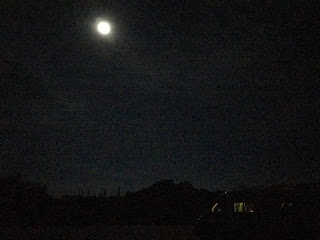
The next 2 nights I found a great spot farther off the road.
I slept with the back and side doors open so the gentle breeze could blow
through my van; the light of the full illuminated the inside of my van through
the screens on each door. It was peaceful and magical. I enjoyed 2 more hikes
from that campsite including my first encounter with a rattle snake. When I
happened upon the mountain lion along the trail in TX, my adrenalin didn’t
surge, but that was not the case with this guy. It was a hot morning as I came
around a corner and the ominous (surprisingly loud!) rattle drew my attention
to a very large snake in the trail, coiled and ready to strike. The snake had
to be at least 6’ long and it looked like it could uncoil and strike as far out
as 3’. Fortunately there was 8’ between us. I yelped and stopped in my tracks,
my heart racing. He slowly slithered off
the trail into the brush; continuing his menacing rattling. I gave him as wide a berth as possible as I
continued down the trail. I’m assuming that a rattler would strike the nearest
object to it, if it felt threatened. I’m hoping my hiking poles, which are
always planted in front of me, would be the target rather than my leg if I
happened to blunder into a snake. But I’ve hiked many miles in the desert and
that was the only close encounter I’ve had.


I could have hiked more than the 10 days I spent exploring
the Superstitions, but duty called. I headed up to Prescott to visit a former
co-worker from 37 years ago, pick up some mail, and see a tax person. From
there I headed to Sedona to meet up with an Alaska friend that I first met when
I lived in Bellingham, WA, 31 years ago. But I’ll save that for another post.


 t
t


