I spent 5 nights in Bandelier National Monument. It’s high desert and
many deep canyons, some with streams. There are large Ponderosa Pines and many
other types of trees and plants. The area attracted me because of its 70 miles
of hiking trails. I
hiked 71 miles in the 5 ½ days (although some trails
I hiked several times to access other trails and some trails I missed).
I started by hiking to the highest point in the area "Cerro Grande" at 10,199'. It was a casual stroll compared to my AZ high point attempt.
The main trail, behind the Visitors Center, is what most people see -- a tour of Tyuonyi pueblo ruins, the long house and the cliff dwellings.
 |
| Looking up toward the cliff dwellings from the pueblo. |
The holes in the rock were where timbers were inserted to build ceilings between multiple floors of structures built against the rocks.
 |
| Hiking down from the campground on Frey's Trail looking at Tyuonyi; the only way into the main area when it was first established as a tourist destination before the road was built. |
 |
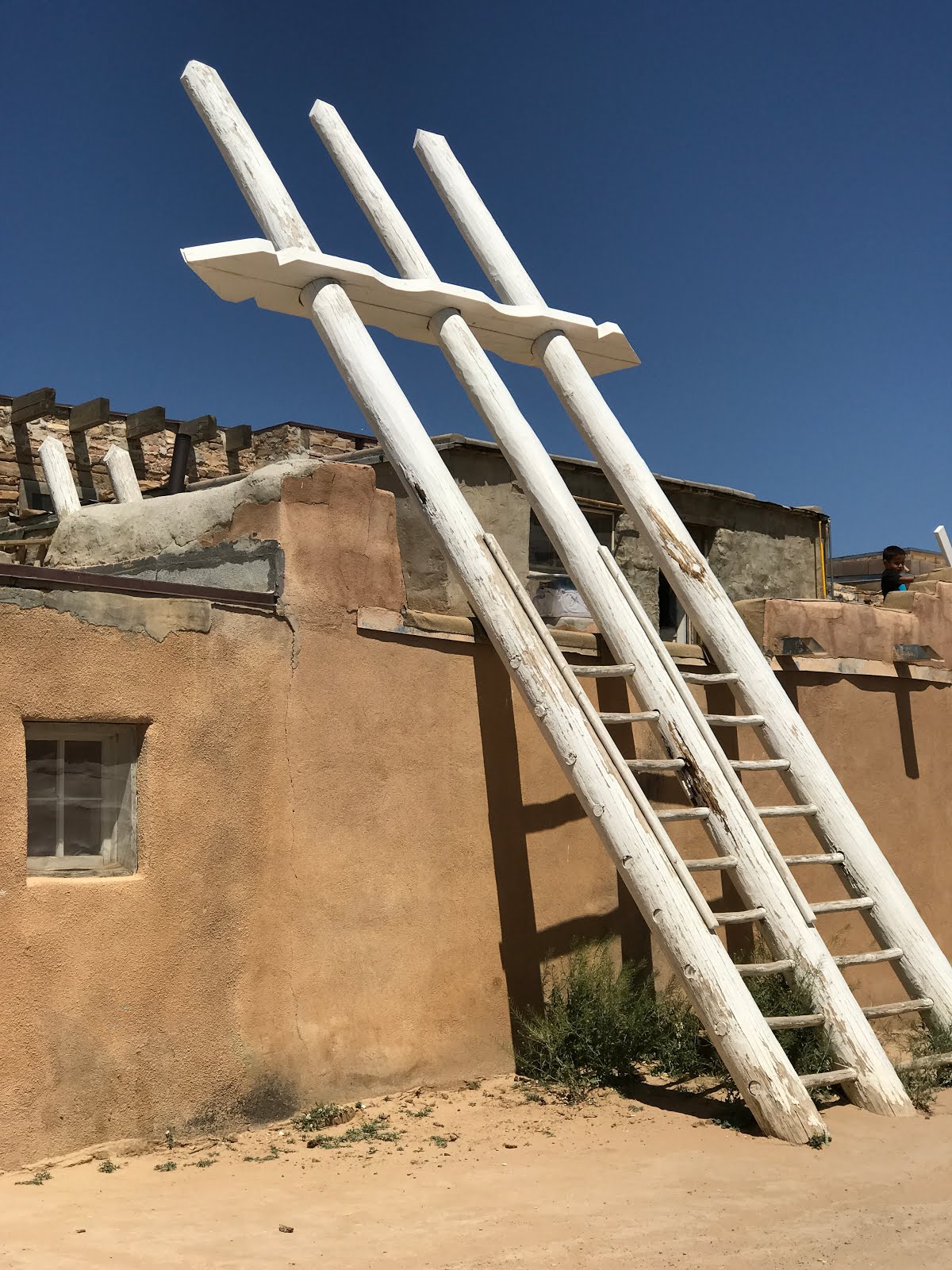
| One of 4 ladders to climb 140 vertical feet to access the Alcove House; a place where ceremonies were held. |
On my 3rd day I tackled a particularly ambitious hike, which involved hitting the trail in the early morning.
 |
| Sunrise on the day of my very long hike. |
I couldn’t decide whether I
was being lazy by not wanting to make it into an overnight backpack trip or
being ambitious by tackling it as a day hike. I wanted to hike back into the
wilderness to see a painted cave with many pictographs. It was a 22 mile hike
with many canyons that you had to hike into and out of for a 3,200’ elevation
gain.
 |
| The descent into Alamo Canyon; 400' down and back up TWICE in the hike! |
 |
| Blooming yucca. |

Hard to say what any of this means, but it's fun to make up stories...
 |
| I was off trail at this point but clearly I wasn't the first person to have walked here... |
My hike wound up being 25.7 miles because I had trouble finding the trail
that looped back on a different route after the painted cave. My route included
some scrambling and bushwhacking – I only had to pull one large, sharp cactus
thorn out of my leg and numerous smaller ones out of my fingers. My GPS said I
was on the move for 10 hours 45 minutes; I got back to my van in the last hint
of daylight.
 |
| View of the Rio Grande on the way back. |

 |
| Looking back at the big canyon in the late afternoon light, after I'd climbed out of it for the 2nd time. Three more smaller canyons to go... |
The next day I “took it easy” and ‘only’ hiked
14 miles, with a 300’ elevation gain. It was apparent that I hadn’t quite
recovered my full energy after my mega hike.
 |
| The hike began by climbing up to the canyon rim and cruising along. |


 |
| The way back was along the canyon bottom. I didn't know I'd be in for scrambling over the aftermath of a major flood several years ago. |
My last day there I tackled a 13 mile hike with 2,200’ elevation gain but I'd recovered my energy by then.
 |
| An ant hill I think. |
 |
| Close up of the ant hill. Either the inhabitants are mini-miners bringing up precious gems from the underworld, or this is crystallized ant exudate... |
 |
| This hike was also along a mesa top (Burro Mesa). As I neared the bluff above Rio Grande flowers were everywhere. |

 |
The trail dropped down to the level of Rio Grande but dumped me into a deep sandy wash. I'd have had to hike several miles to reach the shore of the river. I turned back. The view from above had been much nicer.
OK, that catches me up again FINALLY!!!! (other than my activities in Albuquerque but I'll save that (photos of Pictographs) for another post. Hard to say when I'll have sufficient wireless to post again. . I’m beginning to think I need to invest in a hotspot and a
booster so I’m not out of touch for so long as a result of poor cell coverage
and little to no access to wireless.
Seems like it might be a good time to take a poll. How many of you actually read my posts? And of those that do, how many of you also use Facebook (which I can post to much easier and with lesser cell coverage)? I know when I was "desk bound" I loved vicariously traveling thanks to the blogs of several friends that were off adventuring. I feel like I should pass that on if my posts are something you look forward to. So if it looks like there's sufficient interest from folks that aren't on Facebook and can see my posts there, I'll keep posting a blog when I can.
Happy spring everyone!
|