Saturday, October 29, 2016

Catching up to the here and now!


As long as I make this quick (racing my laptop battery, which I can charge back up each day as I drive) I might actually get caught up!

I am in the land of tiny states with too many roads and too many people; many of which are bad/scary drivers. I am not having fun! Gone is my resolve to drive the back roads and stay off the Interstates. All you see on Interstates are the lines of your lane and the crazy cars darting between lanes, barely missing cars. It's not a way to see the country. But the smaller roads in these heavily populated places have stop lights every few hundred yards and settlement after settlement, ad infinitum.

That said, I still managed to find a few scenic byways here and there that took me through picturesque towns and through pretty scenery. When I saw a place that might have a decent place to get out and wander I took advantage of it, to break up the drive along the Maine shoreline.

.


I stopped in Camden ME pictured above. I know I've heard of it, though I can't remember why. Home of Click and Clack? Or LL Bean?

I got into my campground just before sunset. Living the high life with 110 power to my van and a real, hot shower with unlimited water and no need for quarters to keep it coming. Ahhh the good life! It was a pretty place, due to close down for the season in another few days. I worry about where I'll be able to dump my black water tank as these places all shut down. The tank gauge reads in 1/3s so when it suddenly switches from 2/3 to full I feel a mild panic. How many times after it hits full do I dare use it, before it backs up into the toilet and into my van??? Feels kind of like driving a loaded time bomb! Not a pleasant thought. Must make sure I can always find a dump station when needed.


The campground was scenic enough that it warranted a sunset stroll and a morning stroll (pictured above) before I hit the road again. Where to go on my southward journey? With so many roads it was hard to choose. Cape Cod seemed like a good choice. It's supposed to be a primo holiday destination and it's an interesting geological feature. The online research I did touted their extensive bike paths as 'the perfect way to explore the cape' so off I went in that direction, taking the scenic routes rather than main highways. Slow progress and lots of cars. It took longer than expected to get there. I should've listened to my first inclination to go out of my way, around Boston, rather than through it.  But the GPS kept insisting it was the best/fastest route so I succumbed. Bad idea. Made Seattle's I-5 mess look like a cake walk. VERRRRYYYY slow moving for quite some time to get not very far.

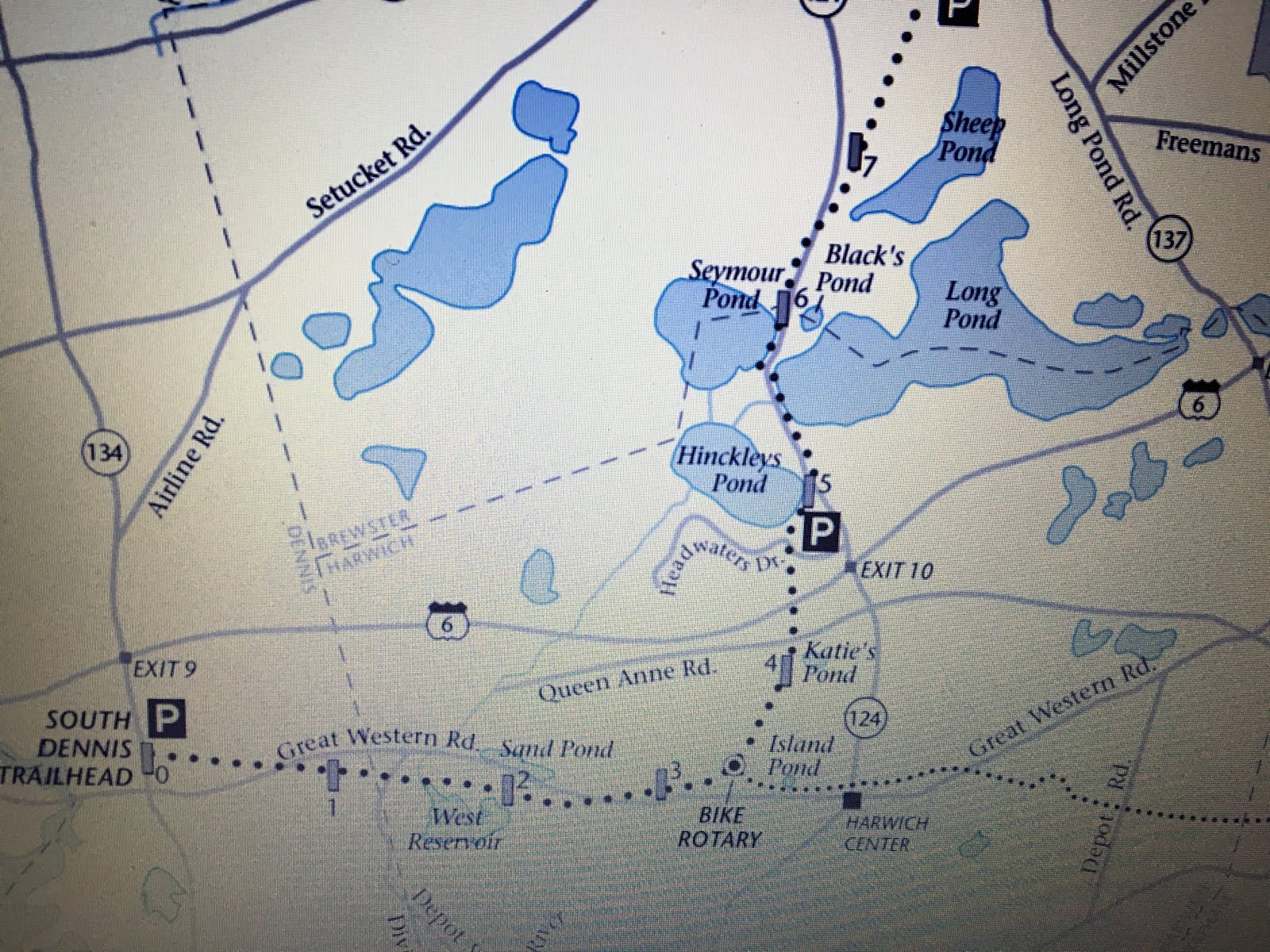
According to my GPS, I thought I'd get to the start of the bike trail at around 10:30; plenty of time for the 44 mile ride I'd planned. But I didn't get started until 2:55. It sounded quite enticing -- Cape Cod bike rail trail. I conjured up images of what I expected to see. It was a nice paved bike trail. It crossed a lot of roads but they had a good motion detector at many of the crossroads that detected a bike approaching and triggered warning lights for motorists. It was 22 miles each way (out & back). The first half of the trail, I rode along some saltwater ponds but the majority of the trail was in a wooded tunnel. I was expecting to see more water. I was sure at the end of it I'd see the cape views I had pictured in my mind, so when it started sprinkling and I was 5 miles from the end I persevered to the end. But, surprise! No view of water, just cars and houses. By the time I got to the end it was raining in earnest and by the time I got back to my van it was nearly dark and I'd been riding in rain and breeze and low 40s temperatures for 2 hours. I was soaked and FROZEN! Thank goodness for my van's heater (for driving) and my RV heater. I used them both to thaw me out and ate a bowl of hot chili. The dotted line on the map in the photo below is the bike trail. The trail itself was nice. I should've taken photos of views on the early part of the trail. On the way back I just had to keep pedaling as fast as I could to get home to my van!


This was the far end of the trail.


I camped there for the night. Even if I wanted to, my frozen feet were in no shape to drive for about an hour after I finished the ride and loaded my bike up. I debated, the next day, about abandoning my exploration of the cape but I was convinced there were amazing views to be had so I drove the long distance to the end of the cape. Again, it was mostly driving without seeing water; just lots of trees and cars and tourist shops and restaurants, most of which were shut for the season. I finally reached the beach near the end of the cape. I imagine in the summer those beach 'houses' would all be full of people.  OK --  been there, done that. I could see the end of the cape, I didn't need to drive there.


I started back up the cape on a different route and decided I should park and get a hike in to a more remote beach in the Shores National Park (or whatever it was called...). The side road I took was heading away from the beach so I pulled off at a parking place and decided to hike across to it. It was nondescript dunes and some brush and small trees but no real trail. I didn't take my GPS, just my phone. I headed on a reasonably straight path toward the presumed beach. There were no I land masses to keep my bearings by, but I paid attention to my direction of travel relative to the sun. It turned out I was hiking toward the airport; no beach in sight. Sigh... I headed back toward my car but by then the clouds were so thick there was no hint of the sun. I had a feel for the direction I needed to go but eventually had to resort to my phone's GPS to tell me where I was relative to the road. I did a bit of circular wandering once I started using the phone before I hit the road. When I got to the road I wasn't sure which way my van was but had a 50% chance of getting it right. Also a 50% chance of getting it wrong. I got the latter and walked probably 1/4 mile each way in the wrong direction. My van was about 50 yards down the road in the other direction. Oh well! It was exercise and the rain held off.

The scenic route back up the other side of the cape took longer than expected (with many more stop lights and road construction  delays) with a few nice views but mostly just driving. Soooo... In retrospect, Cape Cod was not my friend. When I was chatting with my friend on the phone and he was suggesting places to go in the area, he suggested a few big cities and museums and said "I don't know if you want to go to Cape Cod?"  Hmmm... Maybe that was a warning and I should have asked him more about it? Oh well, been there done that. The 'temporarily misplaced' hike I did was yesterday, along with a stroll to the beach in Harwich (still on the Cape) that amounted to just 4.5 miles of walking; but mostly just driving.

As I emerged from the cape and started south again, I came across another accident on the Interstate near Providence, Rhode Island. It look over an hour to move 5 miles. Enough already!!! Siri directed me to yet another Walmart for the night last night and I researched my options. Shenandoah National Park was (theoretically) 8.5 hours drive away on Interstates. The fall colors peaked last week so are still in good shape, there are lots of hiking trails, some of the campgrounds will shut 10/30 but the one with hot showers and laundry will be open for another 2 weeks. So today I drove more than 8 hours (& $26 in tolls) in that direction (I'm in Maryland now), but thanks to several episodes of constricted traffic due to road work and an accident, I still have about 2.5 hours (assuming no more traffic disasters) to drive to get there tomorrow.

I know I passed up some things that would have been interesting to see. I was near Woods Hole Oceanographic Institute, and Mystic Aquarium; I've collaborated with scientists at both of those places and it might have been interesting to stop and tour.  I've never been to New York City (I saw the skyline and some recognizable buildings as I drove past). But I gotta' get away from the traffic chaos and get back to where I can get out and play!!! The forecast for Shenandoah is 70 for a high and 50s for lows. Sounds perfect!

Phew! That catches me up. IF I have cell coverage in the park I might be able to keep caught up. If not, I'll post again when I get out. I'm not sure how long I'll stay. The 100 mile Skyline drive is supposed to be a leaf peepers dream drive but after all this driving I'll be taking that drive in small segments, mostly to get to different hikes.

Since I'd only been sharing the great stuff about my current lifestyle, I figured I better share some of the not-so-great portions too. Figuring out where to go isn't always that straightforward. I'm a simple country mouse. I learned to drive in the country, have never lived in big cities, and I've seldom driven in big cities. So all this driving with all these aggressive drivers has been very stressful. I'm looking forward to getting back to more wide open spaces and fewer cars!!!!

Only 20 minutes of battery left. Time to post and get outta' here.

I hope you all are well!

Maine

Maybe I'll actually get caught up with this post? We'll see how it goes...

So many people have told me how much they love Acadia National Park so it's been prevalent on my must-do list from the get-go (things get a little more vague after that in terms of preconceived ideas of where I need to go next, other than south and west as the temperatures get colder). I didn't hit Acadia in the best of weather. It was in the low 40s with dense cloud cover when I arrived on 10/20 late in the day. Usually when I get to a new (or seldom seen) ocean and walk on the beach I am compelled to walk barefoot in the sand and at least wade in ankle deep. On my wandering the next day, I settled for looking at the Atlantic (what I could see of it through the fog) and kept my shoes on while I strolled on the beach.
Fall colors through the mist. The higher up I went, the less I could see...
The view from Gorham Mountain (day 2 of hiking; for some reason when I try to add a caption it moves this and the last picture above the ones I already put in here for day 1. Oh well... 
 
The rain can be beautiful.

Thar be the sea. If only I could see it!
On day 1 of exploring Acadia I drove the Park Loop Road and did mostly wooded hikes. This is bubble rock. I'm sure there were good views below it, of Bubble Pond at least... I also hiked part of the Gorge Trail and various sections of the seaside trails along the road. It added up to nearly 9 miles, even though I couldn't really see much...


Most of the campgrounds were closed and I was told the one open in the Park  was booked so I headed 15 miles back the way I came in to "camp" (for free) in Walmart's parking lot. There were 5 other RVs there. We sort of segregated in the parking lot; Class B's (vans like mine) migrated to one spot (there were 3 of us) while the big Class A's were in the main parking lot toward the outside. It rained hard that night. I SOOOO love camping in my van on nights like that; counting my blessings that I'm not in a tent. The next day I headed back to the Park. I considered trying The Precipice trail but it's steep with ladders to climb and narrow rock ledges. It was windy and the rocks were slick and the signs cautioned against attempting the trail in those conditions. I only went a short way up and, sure enough, very slick rocks. I headed off to hike to the top of Beehive, which had a few ladder rungs and hand rails of its own and cautioned not to come down that way. I did a long loop route that included Gorham Mountain and came back along a beach trail to my car (a 7 mile hike). The farther up I went on the trail, the more I entered the clouds and the less the view below. Sigh... But I wasn't the only one hiking in the clouds. At least it was exercise! At the end of the hiking I headed into Bar Harbor to check it out (more so than my direct beeline to the Post Office to pick up, fill out, and mail my Absentee Ballot the day before). The waterfront was pretty, filled with lots of touristy shops and restaurants and expensive looking places to stay. A short wander was sufficient for me.


The next day was forecast to be windy but dry. I opted to explore the Carriage Roads in the park. They are logging road width, hard-packed dirt with just a hint of pea gravel. I imagine in the summer, taking a horse-drawn carriage along those roads is quite nice. I rode my hybrid bike but you could probably ride the roads with a road bike. In 49 miles of bike riding (most of the roads available) I saw maybe a dozen other bikers, a good number of hikers, and 1 horse. Given the winding route I took and much of it in sheltered, treed lanes, the wind wasn't that big of a deal. It couldn't always be head winds! It rained for a few brief showers here and there but generally a very nice day.


The next day the sun finally came out. YAY! I hiked a big loop. Starting up the tallest 'mountain' in Acadia (Cadillac Mtn.) from the north side, then down the south side, across Canon Brook Trail, up the south side of Dorr Mountain, down the North side and out to the road via Mt. Kebo (neither a mountain nor a view) and then a mile back along the road to my van (9.82 miles). The views were best coming down the S side of Cadillac (a bit of a zoo up there since you can drive to the top). The views from Dorr were nice too. Hopefully the photos will all land below and I won't try to put captions on them or who knows where they'll wind up landing...


Between the obscured foggy hikes, the long bike ride and the gloriously sunny day where I did the 10 mile loop and once again drove the park loop, I'd pretty much explored the main part of Acadia. There were a few shorter trails I hadn't been on, and a couple of other discreet sections of the park, but the weather was getting colder (below freezing a couple of nights -- I finally fired up my propane heater in my van). It was time to move south. The next day was mostly driving but I managed to get 4+ miles of walks in along the way (Moose Point and Camden, ME) and at the campground (Recompense) that I stayed in that night.


The next day was another mostly-driving day :( but I found a few places to walk along the way for another 4+ miles. With most campgrounds shut down I've become a patron of Walmart parking lots.  They allow RVs to park there for the night; figuring they'll get some sales out of it. They are right. I've been disappointed that many of their stores don't have produce, but I have bought a fair few groceries from them in return for my night-time parking space. Most nights there are at least 4 RVs but this evening's Walmart may not be conducive to the big RVs. I was the only RV here when I pulled in as the sun was setting.

I was going to upload a few more photos but the last one isn't managing to upload so I may have reached a limit for this post.  I will post this now and I think (assuming my laptop battery doesn't die) I might actually be able to catch up in the next post. It won't have too many photos because I haven't taken many in the last few days.

Friday, October 28, 2016

Vermont & New Hampshire fall color splendor


I haven't quite figured this blogging out yet. Photos aren't landing where I want them but hopefully you can figure it out.

Someday I'll catch up to current news... If I hadn’t kept a short log of what I did each day I wouldn’t be able to catch up at all. I’m 2 weeks behind and when I was writing from memory for the last post I said I was heading to hike Mt. Washington in Vermont. I had the state right but the mountain wrong (that mountain is in New Hampshire). From the Adirondacks in NY I headed into Vermont and made my way to Mt. Mansfield, the highest peak in VT at 4,393’.  I took a steep route up to a ridge and then hiked along the ridge to the summit.  I got up there fairly early and the trees were coated with a thick coating of hoar frost. It added a nice contrast to the fall colors visible below.

I arrived at the ridge back where you can  see the radio towers and enjoyed a great view as I continued up the ridge toward the summit.

When I first topped out on the ridge I was surprised to see folks in street clothes. It turns out folks could pay to drive their car up the auto road to a point close to the summit and a 15 minute hike could take them to the summit. Many only went a little way and said “I don’t think it will look much different from there than it does from here” and turned back toward their cars. Mt. Mansfield could be summited from 3 different directions (2 hiking routes, one drive). I had picked the most ambitious route. But, hey, if you don’t “earn it” you don’t appreciate that summit view, right? Or at least not as much…

I took a different route down from the summit of Mansfield.
I drove into the town just north of Mt. Mansfield.

Amazing murals painted on silos in Jeffersonville, VT.
The next day I took care of some business for my Dad’s estate, toured the Ben and Jerry’s Factory, and got in a 7.5 mile hike to the top of Camel’s Hump. It was a sunny weekend day and the summit was packed! The ranger that was stationed up there said it was the busiest she’d seen it all season. That was another summit that was accessible from 3 routes, but all were hiking routes. The last ½ mile all the routes converged so it was very slow following folks up while tons of other folks were making their way down from the summit. I got up there at 3, probably (maybe?) after the worst of the crowds.
Camel's Hump is a popular destination on a sunny weekend day.

View from Camel's Hump. The ranger was pointing out the
peaks associated with Long Trail, an extended hiking route.


 I only drove a short way down the dirt road from the trail head (which was posted for no camping) and found a ­­place wide enough to pull off and camp for the night. 


As long as it’s a public road (hopefully a quiet one) and there’s a place to get well off the road, I generally don’t have a problem hanging out for the night. I’ve spent a few nights at trail heads too. Between driving to charge up my 2 house batteries as I’m heading to my next play destination and the solar panel, I’m happy to say that I’ve spent many more nights “free” camping than paying for campgrounds.  I generally only go to campgrounds or RV parks when I need to empty/fill tanks.

So, after 2 hikes in VT I headed off to New Hampshire. I try to pick scenic byways or smaller roads rather than interstate freeways. And of course VT and NH in the fall have great fall colors. I think some of the scenic byways marked on maps are especially for “Leaf Peepers” as they call us folks sightseeing to take in the fall colors. My NH destination was Mt. Washington, the highest peak in that state and in New England at 6,288’. I wasn’t sure which was the best route up Mt. WA so I spent the day sightseeing and wound up circumnavigating the mountain.
Early on the trail up to Mt. Washington.
View while driving around the mountain.


I hiked up it from the east side, hitting the trail at 7:30 a.m. since the days are getting short. I took Boott Spur Trail up on the recommendation of 2 folks at the visitor’s center. The other 2 routes up from that side go up ravines and don’t get out for views until near the top. Minor details that the wind was HOWLING. It was sustained winds of 50mph with gusts of 65-70 in the forecast for the morning, backing off to 35-40mph in the afternoon with clearing in the forecast. It was no small trick to hike up an exposed ridge in such strong winds. It added a whole new ‘adventure’ to the hike. I had to place my feet very far apart and my hiking poles well out to the sides. If you’ve ever seen a photo of a giraffe with its legs spread so it can get its mouth down to the water for a drink, that’s what I felt like when the winds were gusting from the sides. I was laughing to myself that the prospect of winds of 35-40 was a GOOD forecast. 


The view up the ridge I'm heading for.
Mt. Washington is up there somewhere.
I was hoping there would be a view when I got to the top.


LOTS of people clustered around the summit sign, it was still very windy with gusts to 50mph.

The cog train, or you can drive your car.

It cleared while I was up there.


So many great views on the hike down, and WAY less wind!
Partway up the ridge I entered the clouds. They were sailing overhead, briefly exposing views, but for the most part I couldn’t see the summit I was heading toward. It must be a common condition; the trails had tall cairns placed very close together with a big white rock on the top of each cairn. It wasn’t hard to find my way. I knew before I got there that you could drive your car to the top or take a train so I wasn’t shocked to see hordes of tourists. I even took advantage of the cafeteria and enjoyed a hot bowl of chili and hot cocoa to warm me up. The clouds cleared while I was having lunch so I took the ridge route back down to see the views I’d only had hints of on the way up. It was a 12 mile hike, I got back to my car as the sun was setting. I was VERY happy to be able to take a shower at the visitor’s center, courtesy of the Appalachian Mountain Club. Part of the trail I’d hiked on included a section of the Appalachian Trail. I went back to the same place I’d open-camped the night before; just a quarter mile from the trailhead.

South Moat Mountain.


The next day I didn’t drive far. I wandered around the town of Conway and parked at a trailhead for South Moat Mountain at 3:30 in the afternoon and just hung out. I hit the trail first thing in the morning and had the summit to myself for an hour before other folks started arriving as I was heading down. It’s a popular local hike and I suspect lots of folks chose to play hooky since it was a surprisingly warm fall day. On my hike down the sun was kicking out so much heat that I took off the extra layers and was in shorts and a tank top. The first time in a while. Two of the locals told me that the fall colors are more vibrant this year than they’ve seen in years, so I picked a good year to see my first ever New England fall colors.


I had planned to go join a friend I first met 33 years ago when we were both cycling in Scotland. He was organizing a bunch of friends for a fall foliage campout on the Massachusetts/New York border. Folks were to bring potluck food, hiking clothes, and musical instruments. It sounded too good to pass up so I was going to head west again rather than east as originally planned. But the weather forecast for rain/snow cancelled the 3-day campout so I reverted to the original plan and headed for Acadia National Park. My absentee ballot was waiting for me at General Delivery in Bar Harbor (aka “Bah Haabah”), Maine.
It took most of the day to drive there but the weather is forcing me to pick up the pace. My van is not equipped for freezing temperatures; it’s a 3-season coach. I was hoping I could get to the top of Kathedin – the highest mountain in Maine but it’s in the north of Maine and the weather is getting colder and the days shorter. I called the park where the mountain was told me the forecast was for snow for the weekend and Sat. night was the last night you could camp in the park. After that you’d have to camp outside the park and drive to the trail head in the morning and get back out of the park before 7pm. With fewer daylight hours and needing to drive to get to the trailhead for an ambitious hike, it’s just not feasible at this time of year. So, sigh… I have to let my “high point” pursuit go for ME (for now anyway). That mountain is also the culmination of the Appalachian trail, so it would’ve been nice to get there.
My absentee ballot was calling more to me than getting my annual pass to National Parks (in >4,000 miles of driving, this is the first NP I’ve hit), so I went first to the post office and took care of that and popped it right back in the mail. Then I headed to Acadia and it was too late to get my pass so I found a place to open camp and went back the next morning.

This is getting far too long so I’ll leave it here for now. When I get internet coverage I’ll post this and some photos and then pick up with my Acadia hikes in my next post. But I’m still several states behind since was in Massachusetts when I started this post and I’m now in Rhode Island.  I really will catch up at some point…