Tuesday, February 14, 2017

The rest of TX and into NM

I’ll see if I can get caught up and make this shorter than my last post. I’m trying an experiment and inserting photos into a Word document. I’ll copy and paste to post. Please let me know if the photo quality seems compromised compared to my previous posts. If this works it will save me LOTS of time!  P.S. WAHHHH!!!! It didn't work! I'll need to upload each photo, as long as my freezing fingers can endure. I'm sitting outside a closed store with slow wifi. It's 37 degrees...

I made one more stop at a National Park (NP) in Texas – Guadalupe Mountains NP. The RV “campground” was the least inspiring I’ve seen – it was a paved parking lot with white lines delineating the spaces. The tent camping was a separate but adjoining area but RVs couldn’t choose to go into that area, nor could tents pitch in the RV area. 
That pentagon shaped parking lot in the center of the picture is the "campground".
I suppose I can’t complain; the cost was $8 (half price if you have an all access pass, which I will be able to get once I’m 62) and it WAS a great place from which to hike.  

I arrived in Guadalupe in the late afternoon and squeezed in a 5-mile hike that day to Devil’s Hall.  Hiker’s Staircase (below) was a scenic spot along the trail.

The next day I hiked to the highest point in Texas – Guadalupe Peak (8,749’).  It was just over 11 miles round trip and ~2100’ elevation gain. The view from the top showed a whole lot of nothing – endless stretches of barren landscape.

 It was amazing to think that the first cross-country mail route passed this way. In 1858-1859 the Butterfield Overland Mail Route ran from St. Louis, MO to San Francisco, CA. Six horses or mules, hauling stage coaches, ran day and night, averaging 120 miles a day to cover the 2,700 miles in 25 days (as per the Federal Mail Contract). The stage coaches carried up to 9 passengers, essential baggage, and 12,000 letters. Before this overland route was established, mail was transported from east to west by steamships sailing around the southern tip of South America. The onset of the Civil War resulted in cancellation of the mail contract but it was later replaced by the Pony Express.

Below is a panorama of El Capitan (the monolith I hiked around that day). The high winds did a good job of smearing the clouds.


I hiked a total of 56 miles on 6 trails in as many days, while in Guadalupe. To keep this short, I’ll only share a few details of my other favorite hike in the area – the Permian Reef Trail. The trail gained 2000’ in 4 miles. The elevation gain offered great views, including the border 
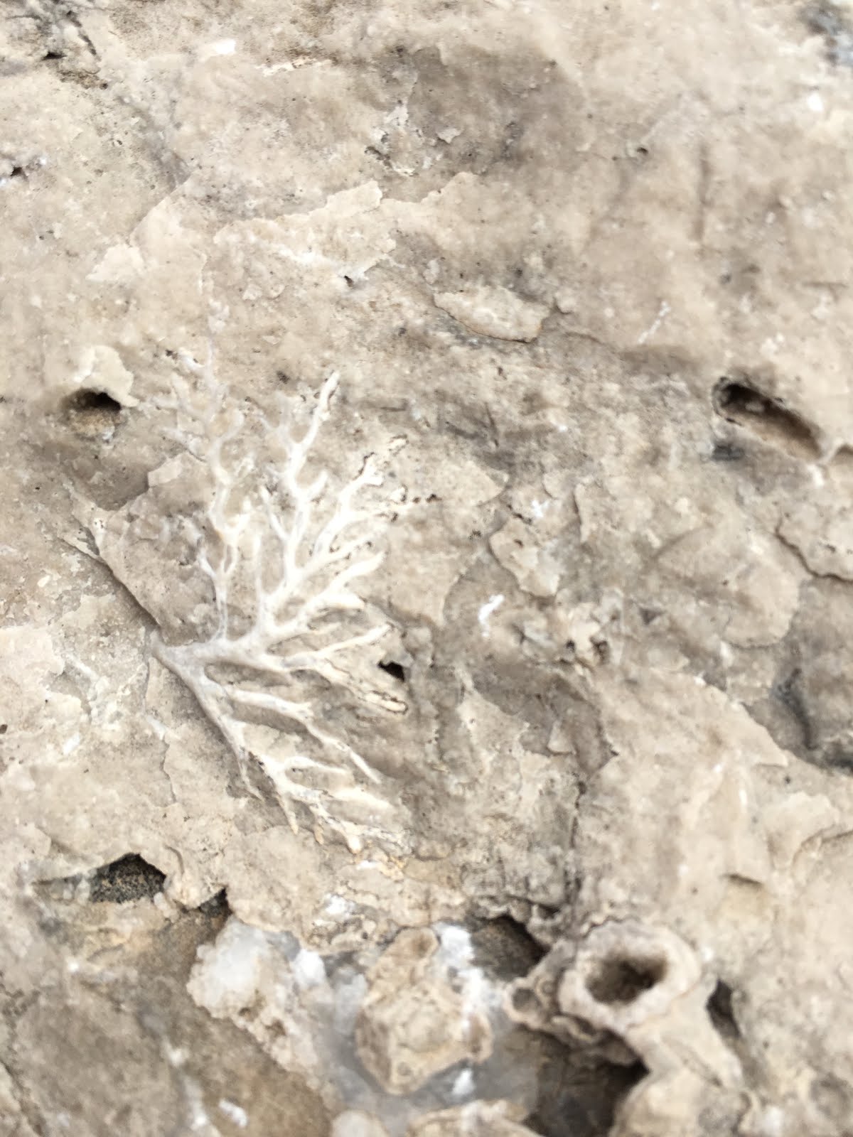
swath that delineated NM from TX. But the best part of this trail was the tiny treasures to be found along the way. Billions of years ago, this area was deep under water and the trail was rich with marine fossils.
 
After one last hike in Guadalupe, I headed into New Mexico and Carlsbad Caverns National Park. I camped 7 miles from the Park and wound up camped next to 2 women with matching silver vans. They had met a few years back at a gathering of a women’s RV club and have taken a number of trips together since then. My van is the sporty, toy-hauler, variety; theirs were more about creature comforts. It was fun to visit with them in the camp ground and the next day in the vast Carlsbad Cavern.
I hesitate to post any photos of that amazing place as the photos do not do it justice.  The place is IMMENSE and jaw-dropping gorgeous. For those of you who have not been there, maybe if I include a photo of the park brochure you’ll get a vague sense of just how big it is.
Photos capture only a miniscule portion in any one view and do not convey the awe-inspiring feel of being there. I was fortunate to visit on a weekday and during a time when the elevator into (and more importantly, out of) the mostly level (8.2 acre!!) “Big Room” portion of the cave was not functioning. That cut out a large number of potential visitors that would not be physically capable of making the steep hike out (about 800’ elevation gain in a mile). After watching one older gentleman unable to catch his breath for what seemed like forever when he stopped to rest on his way up, I asked a ranger how many folks they had to cart out on gurneys due to heart attacks. He said the elevator was out for about 6 weeks last year and they had about one emergency rescue a week. But I digress; the cavern was amazing – almost spiritual. With few people present, it was quiet and, for the most part, private. Although the park info says it takes 1 ½ hours, I spent 4 hours slowly making my way through and marveling at the vast array of natural formations. I took a lot of photos, but the photos really do not do it justice.
I had known I would be heading to Big Bend, Guadalupe, and Carlsbad but my route after that was/is an unknown, which means I spend a good portion of my evenings trying to do some research to pick likely routes and recreation along the way. I know I will be visiting friends NE of Scottsdale and SW of Phoenix, AZ. I may try to meet up with a group of fellow Travato owners at an RV show in Phoenix, and I know I need to find a place to do some repairs on my rig (probably also in Phoenix if they can get me in). The propane system has progressed from being finicky to downright problematic. When it only affected the heat, it was less bothersome, but now it occasionally shuts off the refrigerator when I’m boon docking. Time to see if I can make an appointment and get it fixed while it’s still under warranty.
In choosing my route I was drawn to the promise of >200 petroglyphs at a state recreation area. I made my way in that direction stopping for a hike along the way. As I drove into the New Mexico mountains past a (closed) ski area, I was happy for the 52-degree weather and sunshine. I’m not sure how well my van will drive in snow. Almost getting stuck on a tiny hill in mild mud way back at the Mississippi River has me a bit gun shy. I found a place to stop for a slightly snowy hike in route to the petroglyphs. 

I arrived at the Three Rivers Petroglyphs Recreation Area shortly before sunset, passing up the picnic area to head 8 miles farther up the road to the campground. It turns out the petroglyphs were at the picnic area and I could’ve camped there but, after surviving the last 4 miles (washboard gravel road) of the drive to the campground, I discovered there were hiking trails in the White Mountain Wilderness area, leaving from the campground. The next day I tackled what turned out to be the toughest hike I’ve done so far. It wasn’t the length (12.22 miles) of the Three Rivers Trail or elevation gain (3710’) that whipped me, it was the snow. The last ~2 miles heading up ~1500’ was snowy. I was post holing; no big deal when it was 4-6” deep, but the higher I went, the deeper it got and by the time I topped out at 10,096’ and reached the Crest Trail (where I’d envisioned the warm temps and sun would have melted off the snow) I was at times post holing mid-thigh deep. OOF! It took me 4 hours to hike up; I’d planned to hike along the crest and down a shorter route. Near the top, I’d already taken 2 unnecessary loops, having a difficult time finding the trail (I had an app, but parts of my hike I was out of cell coverage and couldn’t reference where I was on the buried trail). Once I got back on track from the 2nd wayward loop I could see where I had to go (more up and more snow) to hopefully find the trail I’d planned to take down. I had come up the valley in the middle of the picture below, topping out on the snow to the left and making my way to the right. My planned path would’ve led me farther up to through the snow on the right to wrap around that peak and down.
 
As much trouble as I had finding the more popular trail I’d hiked up, I was dubious about finding the needed trail down. I resorted to my mantra “when in doubt, chicken out.” I opted to backtrack the way I’d come, knowing I could follow my footprints in the snow and my GPS track to get me back to my van. The trip down was quicker leaving me time to relocate to the petroglyph site that night in time for a beautiful sunset complete with full moon (! See photo below), and let me begin the next morning exploring ancient culture and art. The mountains in the background is where I’d been hiking earlier that day.
The info I had said it was a half mile trail so I envisioned a short morning stroll with coffee in hand. But that’s only if you’re not curious to scramble among the rocks to find all the hidden treasures and take the trail that goes higher up for even more petroglyphs. I spent nearly 4 hours exploring. A new fact I learned: Petroglyphs are rock carvings, Pictographs are rock paintings.

 
Sadly, there was some graffiti among the impressive petroglyphs. It reminded me of an hypothesis offered up by a professor teaching an Animal Behavior class I’d taken. He’d spent a fair bit of time exploring many famous areas with this type of ancient art work and he suggested that perhaps some of it may have been done by juveniles. If that’s the case, the historic juvenile graffiti artists were far more talented than the contemporary kids adding their initials (and a couple weak attempts at emulating the art).
After the petroglyphs, I stopped in to explore White Sands National Monument. It’s a 5-mile loop drive where you can stop and sled down any of the white sand (gypsum) dunes. I stopped in a few places and walked to the tops of various dunes looking for photos.  I would have thought, with temperatures in the mid-80s that the sand would’ve been hot but it was cool on bare feet.


 From there I headed to Las Cruces, NM, arriving just as it was getting dark. I’d thought about doing a hike in Organ Mountains National Monument (established in 2014) on the outskirts of town the next day but the habitat was very similar to what I’d been hiking in (a continuation of the vast Chihuahuan Desert), so after a night at Walmart (ho hum, but the price is right) I headed toward my next adventure (where I currently am).
I moved from ancient art to ancient homes – the Gila Cliff Dwelling National Monument. It was a scenic drive that took about 4 hours, including driving up into the mountains along some hair pin turns. On the downhill portion of the route, it was a bit disconcerting to think how important functional brakes were to let you slow enough to make those tight turns rather than flying off the cliff if you failed to make the turn. I got here early on a Saturday afternoon and headed from the Visitors Center to the cliff dwellings. The dwellings were built by Puebloans of the Mogollon area; carbon dating the timber used showed the trees were felled between 1276-1287. The structures, a series of 6 caves, were well-designed for climate control; built into a south-facing cliff, during the winter when the sun stays low on the horizon, the sun beams penetrate into the dwellings. The walls didn’t go all the way to the ceilings of the cave to allow smoke from the fires to escape. In the summer when it’s hot and the sun is high, the sun doesn’t reach into the dwellings so it stays cool.

 
I enjoyed the tour but the mile-long hike was just a tease after the long drive, so I managed to get in a 5 ½ mile hike in the adjoining Gila Wilderness to a high point to get a feel for the area. Very different than where I’ve been and very beautiful. Lots of ridges and multiple forks of the Gila River. 
Many of the hikes call for fording the river but recent hot temperatures and snow melt have the rivers running twice as high as is safe to cross. But there were plenty of upper ridge trails that I was looking forward to exploring.

Sadly, a storm was on its way. I camped in a free parking lot/campground and awoke to heavy clouds and occasional distant rumbling thunder. I went to the visitors center to see the forecast; no warnings of thunder and lightning, just .1 to .25” of rain, and winds possibly to 35 mph. I took off on an 11-mile hike and occasionally got a little rain for most of the day.

The last hour of the hike it was a steady light rain. The ground didn’t look that wet but my boots were getting caked with an inch-thick layer of gooey mud. Yuck!  There was a faucet at the trail head so I got the mud off my boots but the 5 steps from the faucet to my van was mud and the caked goo was back.
Clearly, the several additional days of hiking I’d planned here are out. I debated about heading down the mountain at the end of the hike (I had about 1  ½ hours of daylight) but decided to stay. This morning I woke up to some snow.
Not a lot here, but a promise of ½” of precip today and tonight. I wasn’t willing to risk making a drive up/down the various winding, hair pin turns of the road out of here so I opted to stay. I headed the mile back to Gila Hot Springs, moved my van into a muddy RV park and hooked it up to power, and walked down the muddy road to the hot springs. At least the mud where I’m at now is hard packed and not the goo of the hiking trails, but everything is damp and muddy. Yuck! The natural springs are nice; I soaked for more than an hour and then walked back uphill (feeling like a wet noodle after an extended soak in 104-degree water!) to the RV park and enjoyed a thermal hot springs-sourced hot shower.

That catches me up to the here and now. I might be able to get out of here in the early afternoon tomorrow after the snow plows have done anything they need to do and the sun has warmed the pavement. I think the forecast is for a high of 46 degrees. There’s no cell service here anywhere and only 1 source of wifi where I just spent 2 hours uploading photos to go with my jabbering (speaking of which, it’s long again!).

Until later…

Monday, February 6, 2017

Big Bend National Park, TX -- people and hikes

It's getting harder to take a single photo of the route I've traveled so far...
 My 2nd time hiking to the top of the highest point in Big Bend National Park - Emory Peak. My wild hair do courtesy of several days of hiking in high winds (60mph+) and no options for a shower where I'm camped (not even in my van).
This was  my 'almost' view from Emory Peak the first try. I had to go back up 2 days later to see what the view really looked like without dust storms below, rain clouds, and possibly a little smoke from a fire.

Big Bend National Park was wonderful! Besides some amazing hiking and wildlife experiences, I’ve met a fascinating array of people here; some quite inspirational and another that provides a cautionary tale about the importance of pursuing your dreams while you can. This particular older gentleman chatted with me in the campground. When he found out that I was full-time exploring, making it up as I go along, he lamented, “I wish I had done that years ago! I’m recently retired but now I’ve got Alzheimer’s.  I worked really, really hard, and made all this money, and now it’s going to go to waste!” We chatted a while longer and he told me about some Park Service Missionaries he’d met that he was going to do some research on to see if it was a legitimate organization that he might be able to leave some money to.  I hope he can make the fullest out of the time he has left while he can still travel.

The next day, on the summit of the highest point in the Park, I met several gentlemen. They’d been friends for 40 years and continued to get together for annual backpacking trips. More often than not, they go to Big Bend -- it’s a gorgeous area worth repeating. This year they were camped about 3 miles above where their cars were. One man, a physician (one of 2 Mikes that I chatted with extensively as we enjoyed the view), said his 89-year-old father was staying in the lodge below, so he was managing to visit with him and with his backpacking buddies. Not to mention that it gave the men an easy access to Dad’s nice room with a shower.  I had run into Mike on the trail the day before, when he was hiking a loop on his own, on his way to see his Dad. He had intended to hike back up to his camp that evening but said the allure of a bed and hot tub (!!), and the chance to visit more with his Dad kept him at the lodge that night.

Views from the Lost Mine Trail, on the way down from Chisos Basin.

The next day, as I was getting ready to hike up the only other day-hike trail I had left to explore in Chisos Basin -- the Lost Mine Trail (I’d hiked 63 miles in the previous 6 days) -- I pulled into the trail head parking lot at the same time as an older couple. They admired my van and she commented on my bicycle and said she was a cyclist.  I was happy to match the couple’s somewhat slower pace than mine; they were interesting folks and, for being in their mid to upper 70s, they set a healthy pace. After yesterday’s 16.5-mile hike, and 13.5 mile hikes on the previous 2 days, and an 11 mile hike the day before that (all with >2000’ elevation gain), my plan was for an easy day with this 4.8-mile hike, a visit to the Paleontology Center exhibit, and relocating to a new campground. I had plenty of time to enjoy the company of these great folks. We chatted along the way and the 74-year-old woman told me she’d had major back surgery the year before. She had been frustrated with her inability to do much hiking so she focused on bicycling. She said she bicycled 13,000 miles that year. I wondered if perhaps she meant 1,300, but as she described some of the rides, it sounded as if she did—indeed – mean 13,000 (which averages out to 35 miles per day). She has a custom built bike with a good range of very low gears to let her ride up some of the mountains she’s tackled, but it has some higher gears for good road riding. Her husband isn’t quite the avid cyclist she is, but he’s happy to drop her off places and meet her at the other end of her rides, which they do quite often during their extensive travels each year. (Hmmm… I need to find a ‘sag wagon’ driver that’s happy to drop me off for bike rides, hikes, or paddles, and pick me up at the other end!!!). As we hiked, I was busy entering notes into my Iphone of the places they were recommending I should visit during my travels. I so enjoyed their company.

Another view from Lost Mine Trail.

That evening, after I relocated to my new campground in the SE corner of Big Bend along the Rio Grande, I met Casey Zmuch– a 65-year-old long-distance cyclist. As far as I can tell he’s only been doing this for a year or two (he was a long-distance trucker before that and lived in England for a while). He decided he wanted to try it so spent several months working out at a gym, taking spin classes, and doing shorter rides before he hit the road in earnest. He’s currently on a trip that started in New York (having racked up 7300 miles so far), in which he hopes to hit all 4 corners of the nation. He shared many tales with me of his current and earlier adventures and showed me his “Warm Showers” app on his phone, which lists folks that are willing to take in fellow travelers.  The potential hosts put a profile on the app about who they are and what they have to offer (e.g. backyard to camp in, spare bedroom, etc.), and folks using the app also put up profiles of who they are. Who wouldn’t want to take in a white-haired gentleman on an extended cycling trip, with endless tales to tell? After a lengthy, animated chat, I bid Casey goodnight. We both needed to eat dinner and there was no way I had enough supplies on board, or a big enough pan, to cook something to feed both of us. Especially given that he was a hungry cyclist.


The next morning we cycled the 4 miles to the Mexican border, left our bikes with the border guards and, for $5 each, took the “International Ferry” (a row boat) the 20-30’ across the Rio Grande to the Mexican shore near Boquillas Del Carmen, for breakfast. It was an interesting day. I might not have ventured across the border if Casey hadn’t asked me to join him (or might have, I hadn’t really given it any thought yet). It was fun to share the experience and fun to get to speak Spanish again (Casey doesn’t speak the language). From the Mexican shore I had thought to walk the ¾ mile to town but Casey wanted to ride horses. We agreed to pay $8 per horse round trip for the ride to town and back. A guide walked with us to direct us to town. In route I was chatting with him in Spanish and he said he could give us a walking tour in town or if we wanted to keep the horses tied at the edge of town, for an extra $2 each we could stay as long as we wanted in town and ride back on our own; we took him up on the  standby horse taxi.


We had a fun time in town. It’s a poor town. They  used to make their living with mining, but after 9/11 the mines were shut down (because the mine products were exported to the US) and Mexicans were no longer allowed to travel freely across the border. Now they have to drive 160 miles, half on rough gravel roads, to the nearest smallish town in Mexico for supplies, and the only trade for their tiny town is tourism. They had 2 restaurants, what must have been a liquor store that I’m assuming had a few groceries, a church, a school (though it wasn’t in session on a weekday), and a health clinic. There were tourist souvenir displays spread throughout the small village (all looking quite similar to one another), where they attempted to sell needlework and beadwork (wire and bead figurines of scorpions, flower bouquets, etc.). The stands were manned by women, and small children would approach with some of the beaded creatures in hand offering to sell them as tourists approached. Who can resist a cute kid?
Our arrival at about 9a.m. was earlier than most tourists arrived so the town was just waking up and all the displays hadn’t quite been set up.  We strolled around taking photos for a while and politely turning down the low-key sales pitches.  It occurred to me as we were heading back to the restaurant, that if they had $1 bills (they take US dollars) that we could get in change after breakfast, we could go back to all the stands and give the small children a dollar if they would let us take their photos (since we didn’t need/want souvenirs). It was so much fun to do so!


The cook that prepared our tasty meal in her spotless kitchen.
This sign at the restaurant was priceless! It says "No to the Wall".

Once we’d finished our 2nd round of the village on our photo tour we returned to our caballos (horses in Spanish if I could put the ~ above the ll) and headed back in the direction of the Rio Grande. When we saw the sign for the hot springs 0.6 miles away, we decided to “hijack” the horses and go check it out. It was less than appealing (a swimming pool basin to collect the water for a warm dip). Once we’d checked out the tub, we headed back toward the river. Minor details, we ignored where the horses wanted to turn and directed them in a different direction (always trust your horse – they know where the barn is!). Our round trip on the wrong dirt road led us back to where our horses had been tied on the edge of town and we took the proper road direct to our awaiting ferry boat (as if we'd behaved and ridden only that road back). While we’d been in town, other sets of tourists (probably no more than a dozen) arrived in town for their tours. The tourism business isn’t exactly thriving for these folks, at least at this time of year.


After ferrying back across, we cleared US customs (but OOPS, we forgot to go back to Mexico customs to get our exit stamp before we crossed the river again. That might be a problem if I go to Mexico again and they find the stamp without the associated exit stamp. Oh well…). From there we rode to the end of the road on the US side of the river and took a 1.4-mile hike to the Boquillas Canyon overlook. During the night, the Mexicans cross the river and leave some of the same souvenirs that are available in their town on the US side with prices and a jar for $$ so folks can purchase their goods. If Mexicans are caught on the US side they can be arrested. They sit across the river and offer their souvenirs, or offer to sing for $. There was a gentleman singing from across the river as we hiked down the trail (with a much better voice than the 86 year-old-man in town (see picture above) who “played” his very loose-stringed, untuned guitar and “sang” for $). The gentleman across the river offered us souvenirs to purchase, or more singing. I told him he had a nice singing voice but we didn’t put any $ in his jar as we continued on our hiking route. On our way back I told him if he’d sing some more we’d put money in his jar so he sang and we each added a dollar to his collection. Though what we gave to the kids (their families) and the singers, and the tips we gave the “ferry” rower and the horse guide, wasn’t much, it will help them put food on the table. 

As it turns out, Casey, hadn’t originally planned to visit Big Bend National Park. He’d been told it was a “must see” but it was a long ride to the south of his planned route. On the day the winds were gusting to 60-70mph when I was on the highest peak, Casey was walking his bike and trying to stay upright along his cycling route to the north of the Park when a nice man, Kent, picked him up and said he was heading to the park. As with any relaxed traveler, Casey seized the opportunity. He and Kent had been camped for 3 days before I showed up in the same campground. They'd planned to leave the next morning, dropping Casey off where Kent had picked him up, but Casey asked if he could join me for a while as I continued my park exploring. We rearranged my bike rack so it could accommodate the 2 bikes it was designed for and we agreed that he could join me for as long as it worked for both of us. He knew that my main focus was not cycling and I told him I’m used to my private space so I might send him to his tent in the evening, earlier than he might be ready to go there. But for a few days we could do some hiking and biking in the Park, until I got closer to where he was when Kent picked him up and he’d resume his westward bike journey.

View of the Rio Grande during a 14 mile hike in the SE corner of Big Bend. 
Interesting petroglyphs in the Chimneys, near the SW corner of the Park.

Santa Elena Canyon.


Returning to this blog 7 days later, Casey and I shared adventures for 5 ½ days. We biked some and I wore him out on some hikes and left him behind, either at the campsite or resting in my van, on others. He typically rides 65 miles each day with a heavily loaded bike, but isn’t in shape for hiking. We capped off our shared adventures with a fun night in Terlingua, TX, theoretically at the “Ghost Town” which is quite populated with non-ghosts these days. It has a good restaurant (Starlight Theater) and “The Porch”, which is the porch between the restaurant and the Trading Post, where locals gather to watch the sunset and make music. We didn’t make it in time for sunset, but enjoyed a tasty meal after dark, and then joined the locals at a nearby campfire. There was some great guitar playing and singing by several talented locals, with a handful  of other very colorful locals in attendance. Terlingua has only 73 residents, many of whom seem to be on the “fringes” of society. There was the barest sliver of a moon that night so it was an incredible, dark night for star gazing. What better way to watch the stars, than while enjoying the warmth of a campfire and great, live music?! The SW corner of Texas has very few settlements so light pollution is minimal and star gazing is awesome. It was a great night!

Michael, in the foreground, was the other amazing musician. His business card also claims he's a Revolutionary.

Now that I’ve expounded on the people I’ve met recently, allow me to rave about the hiking and wildlife. It’s SO great to be back where there’s some serious hiking options with elevation gain and mileage. On my first night in Big Bend National Park I only had time for a 5-mile hike after I got situated in my campsite in Chisos Basin. I hiked 0.4 miles up hill from my campsite at 5,401’ elevation to where there was wireless available and slightly better cell coverage to make a phone call. Then I hiked down to “The Window”, rumored to be a good place to see the sunset. But it was a narrow window and a blah sunset.

A narrow view from the Window.


 I learned on subsequent nights that it was far better to view the sunset from the “Window View”, several hundred feet and several miles above the actual window.

Near Window View, looking up at the peak that the Lost Mines Trail climbs to.
Sunset from Window View.

The next day I headed up to the highest point in the Park – Emory Peak a 2400’ elevation gain (10.94 mile round trip). It turned out to be a VERY windy day, with high wind warnings (winds 30-50 with gusts of 60-70mph). The last 25 feet to the summit is a rock scramble, made that much more adventurous by the high winds. Fortunately, they were barreling up the front side and hikers were scrambling up the back side. It was too cold to linger on the top and the view was muted, with an odd mix of grey that didn’t exactly look like rain. The winds had kicked up a good dust storm in the desert below and there were sporadic rain drops and there might have been some smoke from fire thrown in. I didn’t linger on the summit.

A bird's nest tucked between thorns.
Muted view from Emory Peak.
On my way back down there were trees down on the trail that hadn’t been there on the way up. Numerous trees at higher elevations had died because of drought a few years back, and the wind gusts that day were doing a number on them. As the stronger gusts hit I checked my immediate surroundings to make sure I wasn’t in range of any dead trees. Two days later, on a clear day I again hiked to the summit for a much clearer view and a more pleasant time on the summit.
The day in between my 2 high-point summits, I hiked the south rim trail and was disappointed when the adjoining Northeast rim trail was closed. The signs said it was due to a 3.5-acre wildfire. I did some serious thinking about whether I wanted to ignore the signs, sure that it was an old fire and it just didn’t make sense to close that many miles of scenic overlook trails for such a small burned out area. I finally talked myself into behaving and hiked the canyon trail to complete my 13.5-mile loop hike. When I met a large, mostly Mexican fire crew hiking in to deal with the fire, I was glad I hadn’t ignored the closed signs.
View along the South Rim Trail.


Two days later I got a “do over” for the south rim/northeast rim (16.5 mile) loop hike because they’d opened the trail by then. That’s the day I was truly blessed with wildlife viewing. Because I’m usually hiking alone, conversations I might be having with a hiking buddy aren’t happening to warn wildlife of my approach so I’ve stumbled across lots of deer and birds at close range. On my round 2 of the south rim hike, I met 2 hikers coming the opposite way. They warned me about the dead dear in the middle of the trail ahead. They had been talking and almost tripped over it because it blended in so well. I thanked them for the warning and we went our separate ways. About 15 minutes down the trail a large mountain lion suddenly stood up on the backside of a clump of brush, about 20 feet away. I stopped in my tracks and he slowly edged off the trail into the woods, about 20’ to the side. We kept watching each other and I gave his prey a wide berth (making it clear I wasn’t challenging him for it) and I moved about 20’ down the trail past the cat to where I had a better view of him and his lunch (it was midday).
He's "hiding" behind the dead, down branches in the middle of the photo.
Now that you know where to look for him, see if you can find him here (if you can zoom in?). His prey was a good-sized buck.


His ears were flattened and his tail swishing initially, but I never felt like he was going to charge me. It was clear he was debating about running away but didn’t sense an immediate danger from me. After a while his ears straightened up and he stopped swishing his tail (all signs of agitation gone) and started grooming himself. At one point he laid his head down and closed his eyes (though his ears were no doubt tuned to any movement I might make that sounded threatening).
He's starting to groom, starting with his bloody mouth, then working on his paws. I'm assuming it was a male due to its large size.

 I was hoping he might return to feed on the deer so I’d have had a better photo of him without the brush he was using for ‘cover’, but he was probably sufficiently satiated for now. After a while we heard conversing hikers approaching and I knew he was going to move away so I took a video of his departure. I don’t know if I’ll be able to post it but I’ll try.

He hears the approaching hikers.


Theoretically the video uploaded. I sure hope it worked. I spent 45 minutes trying. I just previewed it and it looks terrible. It's a lot nicer on my phone or computer!

What an AMAZING experience to watch this beautiful animal for about 10 minutes! Even when I was studying pumas in Chile and radio-tracking collared cats, I never got to see an un-anaesthetized cat for more than a brief moment before he disappeared into the surrounding brush. I was truly blessed that day and ended the day with an amazing sunset.  Life is good!


This is getting quite long and I’ve since moved on to a new National Park (and left it) but didn’t have a chance to get anything posted in the interim. During my time in Big Bend I camped in all 3 camping areas and hiked almost all of the day hikes available. Most of the hikes I did in the rest of Big Bend were considerably shorter than those in Chisos Basin (so I did multiple hikes each day) and none had the high perspective of mountain tops and rims. But they were nice in their own way and allowed an exploration of a much different habitat than the high (and green) alpine of the basin. The hikes included hiking up and down steep gorges (similar to slot canyons), washes, and a hike to a natural hot springs for a soak.
Looking toward Mexico from Rio Grande Village Nature Trail in the SE corner of Big Bend.
My first view of the Rio Grande (other than really tiny through my binoculars from the Park's high point.


A failed attempt at a resort in the SW corner of the Park.
It had a fireplace that could be stoked and enjoyed from both sides. 
And gorgeous views.
Sunset from Sotal Vista.


You can see the hot springs in the lower right of the picture.

All the water from the Upper Burro Mesa drains through this narrow pour spout into the lower mesa.
I had to hike down to the pour spout from the top; many, many washes join up and wind their way down, narrowing as they go. It's easy to image the power that would be here when the rains are hard and it's flooding.

Looking down the pour spout to where the first picture was taken.
 After leaving Big Bend and our Terlingua night of music, I dropped Casey off in the early afternoon in Alpine, TX so he could resume his cycle touring. I headed to McDonald Observatory out of Fort Davis, TX; site of some of the largest telescopes and most renowned astronomical research in the US, thanks to the minimal light pollution of the area.  I joined in on a “Star Party” that begins in an open-air amphitheater where a laser is used to point out and explain what we were seeing for constellations and planets. After that we were able to look through an impressive array of telescopes (some of them requiring their own minidomes to protect the giant scopes, with the ability to rotate the dome so that lthe roof opening would allow the scope to point at (and track) whatever star configuration was programmed into its computer. We had to climb up small ladders to peer into the scopes (more fun than watching a computer display of what the scope was aimed at). The moon was only a slightly larger sliver than the (campfire) night before, so the sky was still plenty dark to allow the attendees to view nebulae, a galaxy (Andromeda) in another universe, star clusters, and 2 magnifications of the moon (including amazing detail in the craters).

The amphitheater where the Star Party will take place, the white dome houses one of the giant scopes we get to look through.  My campsite for the night is to the left of the silver dome seen above.

Setting up a smaller scope to view Orion's Nebulla after the lecture. A dome housing one of the bigger scopes is in the background.The moon and Venus above; you can't see it in the photo but Mars made a triangle with the moon and Venus.

After the 2-hour presentation I drove 5 minutes to a pullout above the Visitor’s Center, and below 2 domes with additional telescopes used for research, and parked to camp for the night. But for the wind, it was a beautiful and quiet night.
I apologize for how long this got! I’m now in Guadalupe Mountains National Park, TX. After I finish my long hike tomorrow (my 3rd here) I hope to be able to hike down to the Visitors Center and use their wireless to get this and some pictures posted.

Rats! I got this partway posted but I'm sitting outside in a cool breeze, the sun is setting,  my computer battery is draining rapidly, the photos are slow to upload, and the wireless keeps kicking me off. I'll see if I can finish it up tomorrow evening.

Take care everyone!