 |
| It's getting harder to take a single photo of the route I've traveled so far... |
 |
| My 2nd time hiking to the top of the highest point in Big Bend National Park - Emory Peak. My wild hair do courtesy of several days of hiking in high winds (60mph+) and no options for a shower where I'm camped (not even in my van). |
 |
This was my 'almost' view from Emory Peak the first try. I had to go back up 2 days later to see what the view really looked like without dust storms below, rain clouds, and possibly a little smoke from a fire.
|
Big Bend National Park was wonderful! Besides some amazing hiking and wildlife experiences, I’ve
met a fascinating array of people here; some quite inspirational and another
that provides a cautionary tale about the importance of pursuing your dreams
while you can. This particular older gentleman chatted with me in the
campground. When he found out that I was full-time exploring, making it up as I
go along, he lamented, “I wish I had done that years ago! I’m recently retired
but now I’ve got Alzheimer’s. I worked
really, really hard, and made all this money, and now it’s going to go to
waste!” We chatted a while longer and he told me about some Park Service
Missionaries he’d met that he was going to do some research on to see if it was
a legitimate organization that he might be able to leave some money to. I hope he can make the fullest out of the
time he has left while he can still travel.
The next day, on the summit of the highest point in the
Park, I met several gentlemen. They’d been friends for 40 years and continued
to get together for annual backpacking trips. More often than not, they go to
Big Bend -- it’s a gorgeous area worth repeating. This year they were camped
about 3 miles above where their cars were. One man, a physician (one of 2 Mikes
that I chatted with extensively as we enjoyed the view), said his 89-year-old
father was staying in the lodge below, so he was managing to visit with him and
with his backpacking buddies. Not to mention that it gave the men an easy
access to Dad’s nice room with a shower.
I had run into Mike on the trail the day before, when he was hiking a
loop on his own, on his way to see his Dad. He had intended to hike back up to
his camp that evening but said the allure of a bed and hot tub (!!), and the chance
to visit more with his Dad kept him at the lodge that night.
 |
| Views from the Lost Mine Trail, on the way down from Chisos Basin. |


The next day, as I was getting ready to hike up the only other day-hike
trail I had left to explore in Chisos Basin -- the Lost Mine Trail (I’d hiked 63 miles in the previous
6 days) -- I pulled into the trail head parking lot at the same time as an older
couple. They admired my van and she commented on my bicycle and said she was a
cyclist. I was happy
to match the couple’s somewhat slower pace than mine; they were interesting
folks and, for being in their mid to upper 70s, they set a healthy pace. After yesterday’s 16.5-mile hike, and 13.5 mile hikes on the previous 2 days, and an 11 mile hike the day before that (all with >2000’ elevation gain), my plan was for an easy day with this 4.8-mile hike, a visit to the Paleontology Center exhibit, and relocating to a new campground. I had plenty of time to enjoy the company of these great folks. We chatted
along the way and the 74-year-old woman told me she’d had major back surgery
the year before. She had been frustrated with her inability to do much hiking
so she focused on bicycling. She said she bicycled 13,000 miles that year. I
wondered if perhaps she meant 1,300, but as she described some of the rides, it sounded as if she did—indeed – mean 13,000 (which averages out to 35 miles per day). She has
a custom built bike with a good range of very low gears to let her ride up some
of the mountains she’s tackled, but it has some higher gears for good road
riding. Her husband isn’t quite the avid cyclist she is, but he’s happy to drop
her off places and meet her at the other end of her rides, which they do quite
often during their extensive travels each year. (Hmmm… I need to find a ‘sag
wagon’ driver that’s happy to drop me off for bike rides, hikes, or paddles,
and pick me up at the other end!!!). As we hiked, I was busy entering notes
into my Iphone of the places they were recommending I should visit during my
travels. I
so enjoyed their company.
 |
| Another view from Lost Mine Trail. |
That evening, after I relocated to my new campground in the
SE corner of Big Bend along the Rio Grande, I met Casey Zmuch– a 65-year-old
long-distance cyclist. As far as I can tell he’s only been doing this for a
year or two (he was a long-distance trucker before that and lived in England
for a while). He decided he wanted to try it so spent several months working
out at a gym, taking spin classes, and doing shorter rides before he hit the
road in earnest. He’s currently on a trip that started in New York (having
racked up 7300 miles so far), in which he hopes to hit all 4 corners of the
nation. He shared many tales with me of his current and earlier adventures and
showed me his “Warm Showers” app on his phone, which lists folks that are
willing to take in fellow travelers. The
potential hosts put a profile on the app about who they are and what they have
to offer (e.g. backyard to camp in, spare bedroom, etc.), and folks using the
app also put up profiles of who they are. Who wouldn’t want to take in a
white-haired gentleman on an extended cycling trip, with endless tales to tell?
After a lengthy, animated chat, I bid Casey goodnight. We both needed to eat
dinner and there was no way I had enough supplies on board, or a big enough
pan, to cook something to feed both of us. Especially given that he was a
hungry cyclist.
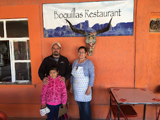
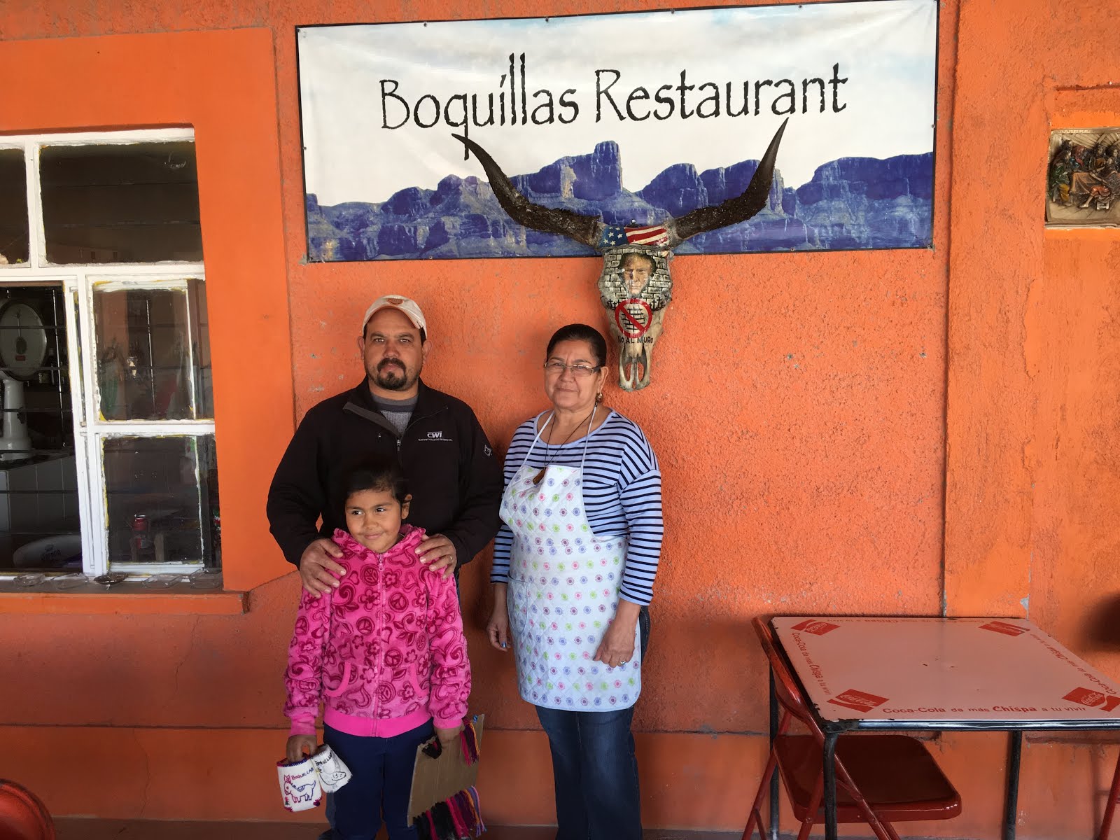
The next morning we cycled the 4 miles to the Mexican
border, left our bikes with the border guards and, for $5 each, took the “International
Ferry” (a row boat) the 20-30’ across the Rio Grande to the Mexican shore near
Boquillas Del Carmen, for breakfast. It was an interesting
day. I might not have ventured across the border if Casey hadn’t asked me to
join him (or might have, I hadn’t really given it any thought yet). It was fun
to share the experience and fun to get to speak Spanish again (Casey doesn’t
speak the language). From the Mexican shore I had thought to walk the ¾ mile to
town but Casey wanted to ride horses. We agreed to pay $8 per horse round trip for the
ride to town and back. A guide walked with us to direct us to town. In route I
was chatting with him in Spanish and he said he could give us a walking tour in
town or if we wanted to keep the horses tied at the edge of town, for an extra $2 each
we could stay as long as we wanted in town and ride back on our own; we took
him up on the standby horse taxi.


We had a fun time in town. It’s a poor town. They used to make their living with mining, but
after 9/11 the mines were shut down (because the mine products were exported to
the US) and Mexicans were no longer allowed to travel freely across the border.
Now they have to drive 160 miles, half on rough gravel roads, to the nearest
smallish town in Mexico for supplies, and the only trade for their tiny town is
tourism. They had 2 restaurants, what must have been a liquor store that I’m
assuming had a few groceries, a church, a school (though it wasn’t in session
on a weekday), and a health clinic. There were tourist souvenir displays spread
throughout the small village (all looking quite similar to one another), where
they attempted to sell needlework and beadwork (wire and bead figurines of
scorpions, flower bouquets, etc.). The stands were manned by women, and small
children would approach with some of the beaded creatures in hand offering to
sell them as tourists approached. Who can resist a cute kid?
Once we’d finished our 2
nd round of the village
on our photo tour we returned to our caballos (horses in Spanish if I could
put the ~ above the ll) and headed back in the direction of the Rio Grande. When we saw the sign for the hot springs 0.6 miles away, we decided to “hijack”
the horses and go check it out. It was less than appealing (a swimming pool
basin to collect the water for a warm dip). Once we’d checked out the tub, we headed back toward the river. Minor details, we ignored where the horses wanted to turn and directed them in a different direction (always trust your horse – they know where the barn is!). Our
round trip on the wrong dirt road led us back to where our horses had been tied
on the edge of town and we took the proper road direct to our awaiting ferry
boat (as if we'd behaved and ridden only that road back). While we’d been in town, other sets of tourists (probably no more than a
dozen) arrived in town for their tours. The tourism business isn’t exactly
thriving for these folks, at least at this time of year.


After ferrying back across, we cleared US customs (but OOPS,
we forgot to go back to Mexico customs to get our exit stamp before we crossed
the river again. That
might be a problem if I go to Mexico again and they find
the stamp without the associated exit stamp. Oh well…). From there we rode to
the end of the road on the US side of the river and took a 1.4-mile hike to the
Boquillas Canyon overlook. During the night, the Mexicans cross the river and
leave some of the same souvenirs that are available in their town on the US
side with prices and a jar for $$ so folks can purchase their goods. If Mexicans are
caught on the US side they can be arrested. They sit across the river and offer
their souvenirs, or offer to sing for $. There was a gentleman singing from
across the river as we hiked down the trail (with a much better voice than the
86 year-old-man in town (see picture above) who “played” his very loose-stringed, untuned guitar and
“sang” for $). The gentleman across the river offered us souvenirs to purchase,
or more singing. I told him he had a nice singing voice but we didn’t put any $
in his jar as we continued on our hiking route. On our way back I told him if
he’d sing some more we’d put money in his jar so he sang and we each added a
dollar to his collection. Though what we gave to the kids (their families) and
the singers, and the tips we gave the “ferry” rower and the horse guide, wasn’t
much, it will help them put food on the table.
As it turns out, Casey, hadn’t originally planned to visit
Big Bend National Park. He’d been told it was a “must see” but it was a long
ride to the south of his planned route. On the day the winds were gusting to 60-70mph
when I was on the highest peak, Casey was walking his bike and trying to stay
upright along his cycling route to the north of the Park when a nice man, Kent,
picked him up and said he was heading to the park. As with any relaxed
traveler, Casey seized the opportunity. He and Kent had been camped for 3 days
before I showed up in the same campground. They'd planned to leave the next
morning, dropping Casey off where Kent had picked him up, but Casey asked if he
could join me for a while as I continued my park exploring. We rearranged my
bike rack so it could accommodate the 2 bikes it was designed for and we agreed
that he could join me for as long as it worked for both of us. He knew that my
main focus was not cycling and I told him I’m used to my private space so I might
send him to his tent in the evening, earlier than he might be ready to go
there. But for a few days we could do some hiking and
biking in the Park, until I got closer to where he was when Kent picked him up and
he’d resume his westward bike journey.
 |
| View of the Rio Grande during a 14 mile hike in the SE corner of Big Bend. |

 |
Interesting petroglyphs in the Chimneys, near the SW corner of the Park.
|
 |
| Santa Elena Canyon. |


Returning to this blog 7 days later, Casey and I shared
adventures for 5 ½ days. We biked some and I wore him out on some hikes and
left him behind, either at the campsite or resting in my van, on others. He
typically rides 65 miles each day with a heavily loaded bike, but isn’t in
shape for hiking. We capped off our shared adventures with a fun night in
Terlingua, TX, theoretically at the “Ghost Town” which is quite populated with
non-ghosts these days. It has a good restaurant (Starlight Theater) and “The
Porch”, which is the porch between the restaurant and the Trading Post, where
locals gather to watch the sunset and make music. We didn’t make it in time for
sunset, but enjoyed a tasty meal after dark, and then joined the locals at a nearby
campfire. There was some great guitar playing and singing by several talented locals,
with a handful of other very colorful locals in attendance. Terlingua has only 73 residents,
many of whom seem to be on the “fringes” of society. There was the barest
sliver of a moon that night so it was an incredible, dark night for star gazing. What better way to watch the stars, than while enjoying the warmth of a campfire and great, live music?! The SW corner of Texas has very
few settlements so light pollution is minimal and star gazing is awesome. It
was a great night!
 |
| Michael, in the foreground, was the other amazing musician. His business card also claims he's a Revolutionary. |
Now that I’ve expounded on the people I’ve met recently,
allow me to rave about the hiking and wildlife. It’s SO great to be back where
there’s some serious hiking options with elevation gain and mileage. On my
first night in Big Bend National Park I only had time for a 5-mile hike after I
got situated in my campsite in Chisos Basin. I hiked 0.4 miles up hill from my
campsite at 5,401’ elevation to where there was wireless available and slightly
better cell coverage to make a phone call. Then I hiked down to “The Window”,
rumored to be a good place to see the sunset. But it was a narrow window and a
blah sunset.
 |
| A narrow view from the Window. |
I learned on subsequent nights that it was far better to view the
sunset from the “Window View”, several hundred feet and several miles above the
actual window.
 |
| Near Window View, looking up at the peak that the Lost Mines Trail climbs to. |
 |
| Sunset from Window View. |
The next day I headed up to the highest point in the Park –
Emory Peak a 2400’ elevation gain (10.94 mile round trip). It turned out to be
a VERY windy day, with high wind warnings (winds 30-50 with gusts of 60-70mph).
The last 25 feet to the summit is a rock scramble, made that much more
adventurous by the high winds. Fortunately, they were barreling up the front
side and hikers were scrambling up the back side. It was too cold to linger on
the top and the view was muted, with an odd mix of grey that didn’t exactly
look like rain. The winds had kicked up a good dust storm in the desert below
and there were sporadic rain drops and there might have been some smoke from
fire thrown in. I didn’t linger on the summit.
 |
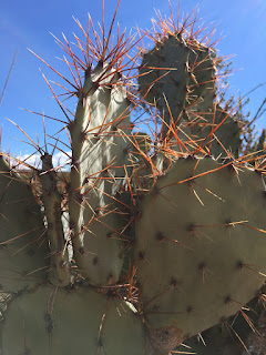
| A bird's nest tucked between thorns. |
 |
| Muted view from Emory Peak. |
On my way back down there were
trees down on the trail that hadn’t been there on the way up. Numerous trees at
higher elevations had died because of drought a few years back, and the wind
gusts that day were doing a number on them. As the stronger gusts hit I checked
my immediate surroundings to make sure I wasn’t in range of any dead trees. Two
days later, on a clear day I again hiked to the summit for a much clearer view
and a more pleasant time on the summit.

The day in between my 2 high-point summits, I hiked the
south rim trail and was disappointed when the adjoining Northeast rim trail was
closed. The signs said it was due to a 3.5-acre wildfire. I did some serious
thinking about whether I wanted to ignore the signs, sure that it was an old
fire and it just didn’t make sense to close that many miles of scenic overlook
trails for such a small burned out area. I finally talked myself into behaving
and hiked the canyon trail to complete my 13.5-mile loop hike. When I met a
large, mostly Mexican fire crew hiking in to deal with the fire, I was glad I
hadn’t ignored the closed signs.
 |
| View along the South Rim Trail. |


Two days later I got a “do over” for the south rim/northeast
rim (16.5 mile) loop hike because they’d opened the trail by then. That’s the
day I was truly blessed with wildlife viewing. Because I’m usually hiking
alone, conversations I might be having with a hiking buddy aren’t happening to
warn wildlife of my approach so I’ve stumbled across lots of deer and birds at
close range. On my round 2 of the south rim hike, I met 2 hikers coming the
opposite way. They warned me about the dead dear in the middle of the trail
ahead. They had been talking and almost tripped over it because it blended in
so well. I thanked them for the warning and we went our separate ways. About 15
minutes down the trail a large mountain lion suddenly stood up on the
backside of a clump of brush, about 20 feet away. I stopped in my tracks and he
slowly edged off the trail into the woods, about 20’ to the side. We kept
watching each other and I gave his prey a wide berth (making it clear I wasn’t
challenging him for it) and I moved about 20’ down the trail past the cat to
where I had a better view of him and his lunch (it was midday).
 |
| He's "hiding" behind the dead, down branches in the middle of the photo. |
 |
| Now that you know where to look for him, see if you can find him here (if you can zoom in?). His prey was a good-sized buck. |

His ears were
flattened and his tail swishing initially, but I never felt like he was going
to charge me. It was clear he was debating about running away but didn’t sense
an immediate danger from me. After a while his ears straightened up and he
stopped swishing his tail (all signs of agitation gone) and started grooming
himself. At one point he laid his head down and closed his eyes (though his
ears were no doubt tuned to any movement I might make that sounded
threatening).
 |
| He's starting to groom, starting with his bloody mouth, then working on his paws. I'm assuming it was a male due to its large size. |
I was hoping he might return to feed on the deer so I’d have had
a better photo of him without the brush he was using for ‘cover’, but he was
probably sufficiently satiated for now. After a while we heard conversing hikers
approaching and I knew he was going to move away so I took a video of his
departure. I don’t know if I’ll be able to post it but I’ll try.
 |
He hears the approaching hikers.
|
Theoretically the video uploaded. I sure hope it worked. I spent 45 minutes trying. I just previewed it and it looks terrible. It's a lot nicer on my phone or computer!
What an
AMAZING experience to watch this beautiful animal for about 10 minutes! Even
when I was studying pumas in Chile and radio-tracking collared cats, I never
got to see an un-anaesthetized cat for more than a brief moment before he
disappeared into the surrounding brush. I was truly blessed that day and ended
the day with an amazing sunset. Life is
good!


 |
| A failed attempt at a resort in the SW corner of the Park. |
 |
| It had a fireplace that could be stoked and enjoyed from both sides. |
 |
| And gorgeous views. |
 |
| Sunset from Sotal Vista. |


 |
| You can see the hot springs in the lower right of the picture. |
 |
| All the water from the Upper Burro Mesa drains through this narrow pour spout into the lower mesa. |
 |
| I had to hike down to the pour spout from the top; many, many washes join up and wind their way down, narrowing as they go. It's easy to image the power that would be here when the rains are hard and it's flooding. |
 |
| Looking down the pour spout to where the first picture was taken. |
After leaving Big Bend and our Terlingua night of music, I dropped Casey off in the early afternoon in Alpine, TX so he could resume his cycle touring. I headed to McDonald Observatory out of Fort Davis, TX; site of some of the largest telescopes and most renowned astronomical research in the US, thanks to the minimal light pollution of the area. I joined in on a “Star Party” that begins in an open-air amphitheater where a laser is used to point out and explain what we were seeing for constellations and planets. After that we were able to look through an impressive array of telescopes (some of them requiring their own minidomes to protect the giant scopes, with the ability to rotate the dome so that lthe roof opening would allow the scope to point at (and track) whatever star configuration was programmed into its computer. We had to climb up small ladders to peer into the scopes (more fun than watching a computer display of what the scope was aimed at). The moon was only a slightly larger sliver than the (campfire) night before, so the sky was still plenty dark to allow the attendees to view nebulae, a galaxy (Andromeda) in another universe, star clusters, and 2 magnifications of the moon (including amazing detail in the craters).
 |
| The amphitheater where the Star Party will take place, the white dome houses one of the giant scopes we get to look through. My campsite for the night is to the left of the silver dome seen above. |
 |
| Setting up a smaller scope to view Orion's Nebulla after the lecture. A dome housing one of the bigger scopes is in the background.The moon and Venus above; you can't see it in the photo but Mars made a triangle with the moon and Venus. |
After the 2-hour presentation I drove 5 minutes to a pullout above
the Visitor’s Center, and below 2 domes with additional telescopes used for
research, and parked to camp for the night. But for the wind, it was a
beautiful and quiet night.
I apologize for how long this got! I’m now in Guadalupe
Mountains National Park, TX. After I finish my long hike tomorrow (my 3rd
here) I hope to be able to hike down to the Visitors Center and use their
wireless to get this and some pictures posted.
Rats! I got this partway posted but I'm sitting outside in a cool breeze, the sun is setting, my computer battery is draining rapidly, the photos are slow to upload, and the wireless keeps kicking me off. I'll see if I can finish it up tomorrow evening.
Take care everyone!


No comments:
Post a Comment