

Sunset at Spider Rock at the end of the south rim.
 e
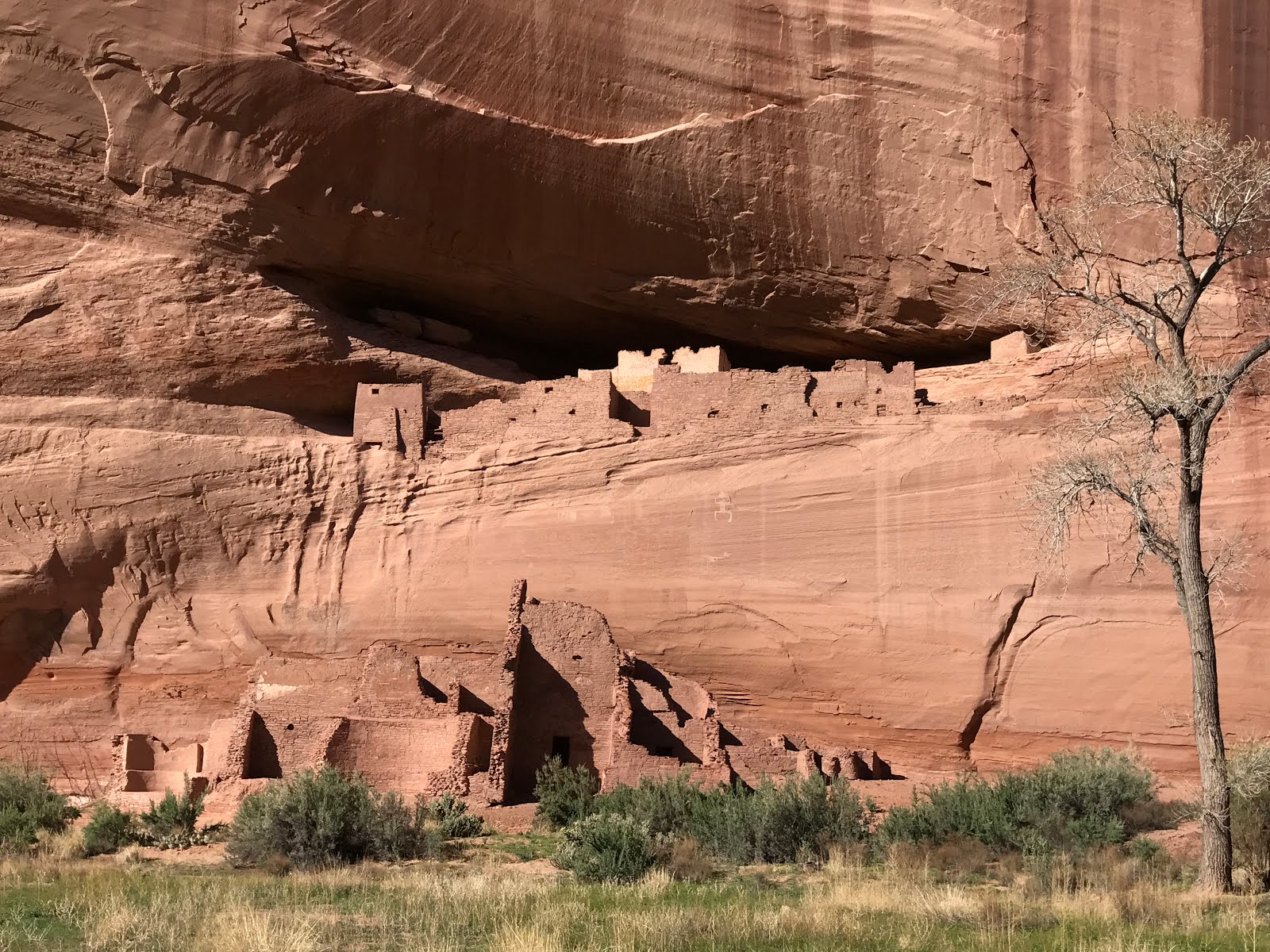
eRuins seen from the north rim.


After Chaco I drove through Navajo Reservation lands, still in Arizona. They’re huge but most of it is barren wasteland that would be difficult to live on. I ventured off the main highway and into Navajo National Monument; jointly run by the National Park Service and the Navajo Nation. I was amazed to discover that there was no entry fee and no charge for camping at one of their 30 first-come-first-served camp sites. They had 3 trails, the best was the paved trail to an overlook of a cliff dwelling. Starting in mid-May they take tours down to the dwellings.


It was a clear night with a sliver moon. The site
is well away from any towns so there’s no light pollution and they were going
to have a Star Party that night that a NASA scientist was going to present. The
scientist failed to show up but the staff drug out the 2 small telescopes they
had and managed to get them focused in on the moon after a while, and on one
unidentified star. Quite a few locals showed up for the occasion with their
children in tow. A local gentleman who works with kids volunteered to give an
impromptu presentation on what he knew about the stars. He did an impressive
job. The Navajo children theoretically finished their study handout and
answered all the questions to become a “Night Ranger”. But with the endless
running around (such energy!) that the kids were doing it’s hard to imagine
where they found time to complete the module. Nonetheless, they were all sworn
in as Junior Rangers while we were waiting for it to get dark enough to use the
telescopes.

Without a NASA scientist to guide the use of the telescopes and
identify the stars it was a little disappointing. But it was something to see
an elderly Navajo woman leaning on her cane and peering into a telescope
focused on the moon. Several Navajo women were taking photos of her so they
were also struck by the incongruity. Initially they hadn’t figured out how to
focus the telescope so the moon sliver was blurry, but they got it focused
after a while and you could see the craters. The things that Navajo elder has
seen in her lifetime!

I moved on to the Glen Canyon Recreation Area, starting out
at Lake Powell for a couple of days.


The "must do" hike that everyone does to Horseshoe Bend, just outside of Page. You can see the parking lot from a long ways away, filled with many cars, RVs, and a few buses.
From there I headed into Utah to the Grand
Staircase-Escalante National Monument (GSENM). It’s a huge NM (1.9 million acres)
but access to most of it requires a 4WD. I had hoped to hike Buckskin Gulch
slot canyon and even try my luck at getting a lottery permit to hike the Wave
but after the rains they’d had there was no change my heavy, low clearance,
front-wheel drive could safely access the locations I wanted to hike. This is
the first time I haven’t been anything but ecstatically happy with my van. If
only it was 4WD with higher clearance. Oh well… So I didn’t get into the slots
I’d heard about. I watched as about 50 people went into a room at the Rangers
Station to see which 10 would get the lottery draw that day. And of course if
the first lucky draw has a group of 6, that leaves only 4 permits left. I left
the station confused about where I was going to go to hike that day. The
tourist info a few blocks away solved that for me by telling me that I could
hike in nearly 4 miles on a sandy 4WD road to access a small slot canyon. A
tiny version of Buckskin or the Wave but interesting and colorful. So I got my
slot fix and some photos. Not quite the famous “Wave” but the gist of it.


Where to next? That’s been my dilemma for a while. This is
the first time in 7+ months of travel that I’ve been confused about where it is
I should be going. When I came out the north end of Chaco, the nearby sites I
had heard about and wanted to hike were surrounded by ski hills. The snow
visible on the mountains around me made it clear I wasn’t going to be able to
access those sites. I came too far north
too soon. I’ve been casting about since then trying to figure out a good plan
of attack to continue my explorations and have plenty of time for challenging
hikes.
 .
.
I spend many evenings contemplating maps and tourist info I've picked up, or searching the web if I'm lucky enough to have internet or a decent cell connection.
After the Peek-a-Boo slot canyon, I spent more time
contemplating maps (which way to go to avoid the hot temperatures of farther south
and the snow of higher elevations that had things I really wanted to hike?). I
went to bed with a plan for where to next. The next morning, before I even
started up the van, I changed my mind and headed to Zion National Park – a
short drive away. Zion is the first place I’ve been to in my van that I’d
previously been to. But since I’d hiked in Zion and Bryce in a 10-day vacation
previously, I knew I couldn’t possibly have seen it all. But my, oh my, SOOOOO
many people! I stayed 5 nights and enjoyed being able to bypass the huge waiting
lines to get on the bus shuttles that drove folks up into the canyon. I rode my
bike instead and locked it at the various trail heads. It was nice to ride the
canyon road, since few cars were allowed up there and buses only passed by
infrequently. I got in some “biathalons”
with 22-36 miles per day of self-powered (biking and hiking) travel.
When I got to Zion it was a rainy day so I hiked into town (Springdale) to get some groceries and browse. I found a good motto to live by:


After shopping I did a muddy hike up Watchman by the campground. Fortunately the weather cleared after that.

I hiked to Observation Point and was checking out the view with my binoculars; someone with a nice camera took this photo and sent it to me.

The "must do" hike here is to Angel's Landing. This is Walter's Wiggles, 27 steep switchbacks. There were WAY to many people trying to get up the bottleneck in the trail where you need to hang on to a chain to negotiate a particularly vertical spot. I passed it by and continued to hike higher for several miles, leaving most of the people behind.


Angel's Landing is the skinny rock in the middle of the photo.

Angel's Landing is around the corner and a long way down from this view. I was surprised how much the view opened up.


The bike ride to the hiking I did in Zion. Very few cars were allowed on this road. Instead the multitude of people crammed into buses that passed by periodically. Mostly it was a quiet peaceful ride adn thankfully it was downhill going back after a long day of hiking.


Beautiful views on the way into Hidden Canyon. The chain on the left is a reassuring handhold.


The hike into Hidden Valley has a number of narrow ledges with a chain to hang onto to keep solid footing on the sand-coated slickrock. I was amazed at how many young children were on that route. Brave parents!

There were WAY too many people on the easier hikes like this one to Emerald Pools. I tried out my fisheye lens to capture the chaos.


On my way out of Zion I headed up a side canyon to hike through Hop Canyon.

Another painfully slow wireless connection. After several hours of struggling I switched to my phone's hotspot but it's not much faster. Sigh...
I'm a long ways from being caught up but making progress. I may have to look into investing into a hotspot and cell booster to end this frustration.
No comments:
Post a Comment