Boy oh boy was I behind on my running total of my hiking
miles when I gave my ‘taking stock’ report last time. I just caught up on the
math. As of 4/24/17, I’ve hiked 2,938 miles and walked 4,876,593 steps since
starting this lifestyle 232 days ago. Those are Iphone miles. I always have my
Iphone with me. I only track my miles with my GPS when I’m setting out on a
long hike or bike ride (as opposed to numerous short jaunts in a day). I’ve
logged 1,648 GPS miles. My Iphone tends to slightly overestimate hiking mileage
but definitely way underestimates biking miles (of which I've done several hundred) so I’ve definitely self- powered
for a minimum of 2,829 miles.
As I wrote this first part I was 5-star camping (electricity
and water) at Lake Mead (I think it was still in NV) and thought I’d be able
to make an attempt to get closer to catching up here. As usual for RV parks
that advertise free wireless, I was having trouble getting onto the internet.
But at least I got started on a Word document without having to worry about my
laptop battery dying. I can add it to the
post if they get the internet fixed.
Last time I had internet I posted a bunch of photos of Chaco
Culture National Historical Park. It’s a pretty amazing place. Could be the
photos look like a bunch of piles of rubble and wall fragments. What can I say?
Cameras have no emotions. But the place is huge and inspires one to imagine
what it must have been when fully intact and occupied. It was believed to be
the administrative headquarters of the Ancient Puebloans (formerly referred to
as Anasazi, which is a derogatory term meaning “ancient enemies”).


Year round there were believed to only be a couple of hundred people, but during the more hospitable weather the area was believed to host around 2,000 people. There were numerous outlying smaller establishments and all the roads connecting the outlying communities with the admin center were constructed on north-south and east-west tangents. If something was in the way (e.g., a rock wall) they cut steps into the wall to get up and over it rather than deviating to find a way around. The roads were up to 9’ wide as they got closer to the admin HQ. There were numerous eras of building styles that occurred for an extended period of time and then the sites were all abandoned. No one knows why, but it’s presumed that it was due to climate change or lack of sufficient resources making the area no longer livable. Certainly, as I hiked to all the outlying areas and explored the HQ I was struck by how arid the landscape was.


Imagine all the time it would take to stack all those TINY stones!!! And the timbers were carried from very far away.


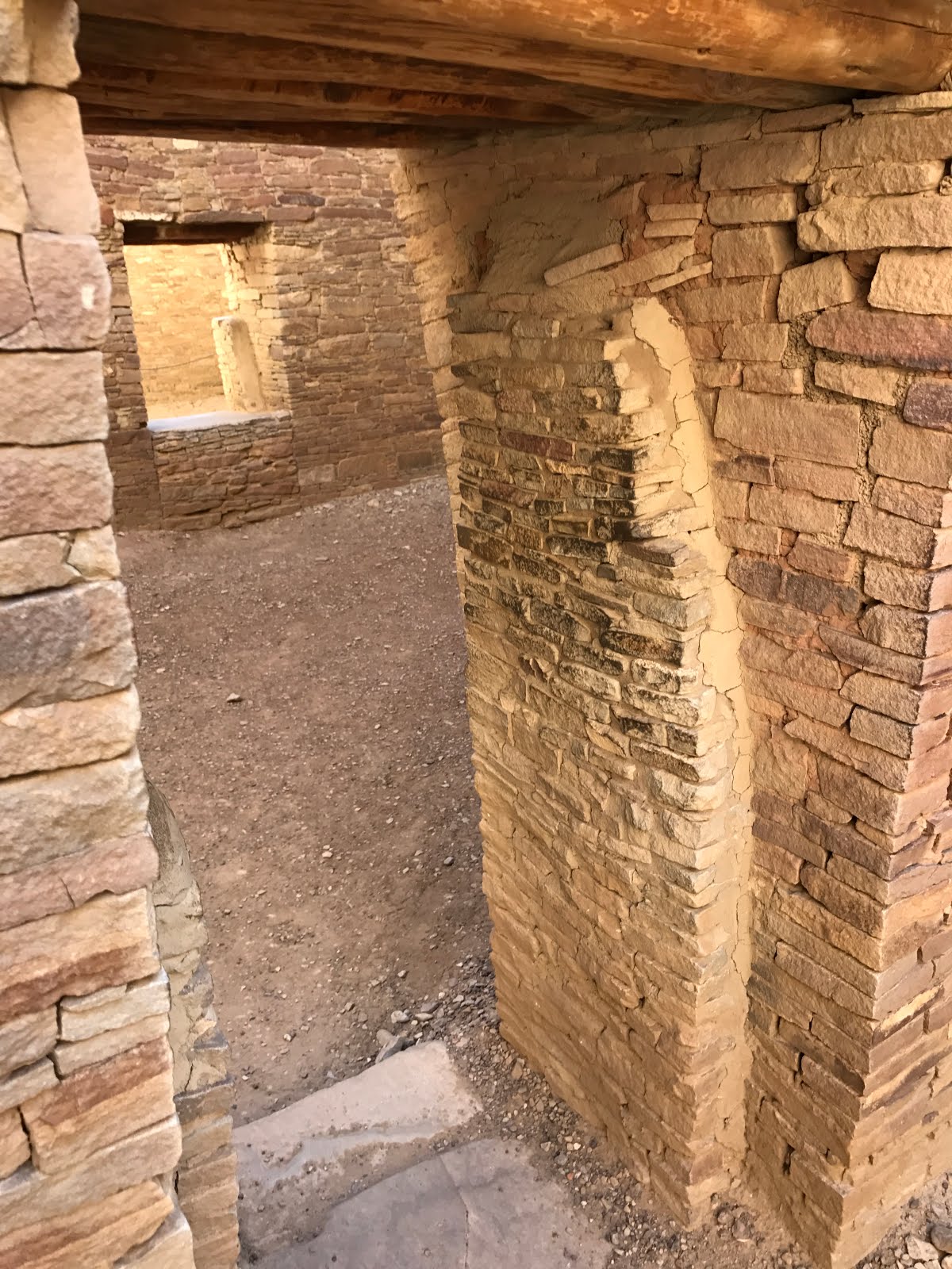

The only room with the original ceiling.


The rooms went on and on!


The roads were built North-South East-West (perhaps to facilitate gathering at the central location. If something was in the way they didn't go around, they carved steps to get up over it.


 |
| These pictographs were aged back to when a Super Nova was occurring and may depict what the ancient puebloans were seeing. |

This was a distant pueblo, high atop a mesa.


Getting out of Chaco was far more challenging than getting
into it. Whether you use the south or north entrance, you are looking at 20
miles of dirt roads to reach/leave the park. They occasionally grade the south
road and I must have hit it after recent road maintenance. I’d been dreading
the long dirt-road drives since everything in my van rattles rather loudly when
the roads are rough. But the south entrance was pretty nice. I was able to go
about 35mph. The road didn’t get bad
until I actually entered Chaco. For about 500 yards it was bone-rattling
washboard dirt and then I hit pavement. Ahhh… Folks coming in from the north
reported what I’d heard and feared – deep ruts and washboard the whole 20
miles. Yuk! That was enough to convince me to head out the south entrance
rather than brave the north road when it was time to leave.
While I was in the park, exploring all the ruins and hiking
everything there was to hike, it rained for a few hours several days in a row. The
last (long) trail I hiked was gooey slippery mud in a few stretches. When I was
ready to leave, the Park Service folks advised me that the south road turns to
goo when it’s been raining and there’s no cell coverage. If I headed down that
way I was likely to get stuck and no one would be available to rescue me.
Enough said. I headed out the north entrance and it wasn’t fun. It took me
about 3 times as long to cover the 20 miles. I got out at one point to check
the width of and distance between my tires relative to the ridges I needed to
stay on top of to avoid settling into the ruts. I’m pretty sure I would’ve
wound up high-centered on the ridges if I’d dropped into the ruts. A couple of
times I took a highly canted path along the side of the road rather than brave
the ridges and ruts. As my van was leaning sideways my years of bicycling and
kayaking had me leaning hard to the opposite side in a vain effort to keep my
craft balanced. I couldn’t help but laugh at myself. My body weight certainly
can’t counterbalance a 3500 pound (short) RV rig. Thankfully, I managed to
survive the drive out with no damage to my rig. Phew! I would do it again. The sights were amazing and it was peaceful and
mystical. The dirt roads probably spook some people away so it wasn’t as
overcrowded as some other spots have been (e.g., Zion!!!).
 |
| Chaco is an amazing place, but ya gotta work for it. 20 miles in on dirt roads. The north entrance (this one) is, according to one of the Park rangers, "Always consistently bad." When it wasn't deep ruts it was bone-jarring, van-rattling washboard. |
 |
| Clearly, someone didn't take this road too seriously. This bumper and 2 fenders were scattered along the way. |
No comments:
Post a Comment